File:Christopher Columbus voyages map-fr.svg

此 SVG 檔案的 PNG 預覽的大小:800 × 523 像素。 其他解析度:320 × 209 像素 | 640 × 418 像素 | 1,024 × 669 像素 | 1,280 × 836 像素 | 2,560 × 1,673 像素 | 1,922 × 1,256 像素。
原始檔案 (SVG 檔案,表面大小:1,922 × 1,256 像素,檔案大小:399 KB)
摘要
| 描述 |
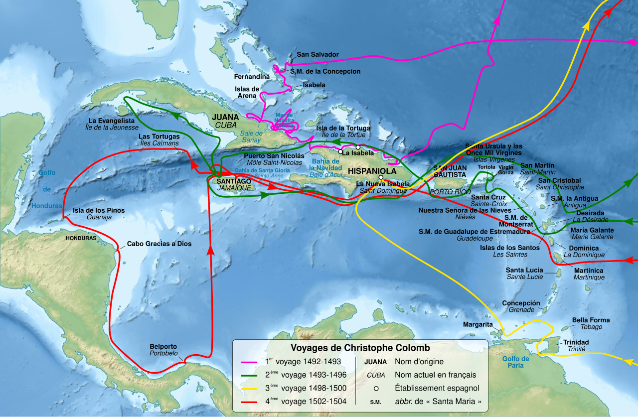
English: Map of Christopher Columbus voyages, between 1492 and 1504. Français : Carte des voyages de Christophe Colomb, entre 1492 et 1504. Equirectangular projection, WGS84 datum
Geographic limits of the map:
|
||
| 日期 | |||
| 來源 |
自己的作品. Sources : Data :
|
||
| 作者 | Sémhur (talk) | ||
| 其他版本 |
Derivative works of this file: Christopher Colombus first voyage 1492-1493 map-fr.svg | ||
| 姓名標示 (由许可协议要求) | © Sémhur / Wikimedia Commons / | ||
| SVG | W3C-validity not checked. 本vector image使用Inkscape創作 .
|
||
| Graphic Lab |

| 拍攝地點 | | 位於此地的本圖片與其他圖片: OpenStreetMap |
|---|
授權條款
我,本作品的著作權持有者,決定用以下授權條款發佈本作品:
| 公共版權:本藝術作品是自由的,您可以依據自由藝術作品許可協議的條款傳播和/或修改本藝術作品。您可以在Copyleft Attitude網站或其他網站找到該許可協議的樣本。 |
This file is licensed under the Creative Commons Attribution-Share Alike 4.0 International, 3.0 Unported, 2.5 Generic, 2.0 Generic and 1.0 Generic license.
- 您可以自由:
- 分享 – 複製、發佈和傳播本作品
- 重新修改 – 創作演繹作品
- 惟需遵照下列條件:
- 姓名標示 – 您必須指名出正確的製作者,和提供授權條款的連結,以及表示是否有對內容上做出變更。您可以用任何合理的方式來行動,但不得以任何方式表明授權條款是對您許可或是由您所使用。
- 相同方式分享 – 如果您利用本素材進行再混合、轉換或創作,您必須基於如同原先的相同或兼容的條款,來分布您的貢獻成品。
您可以選擇您需要的授權條款。
檔案歷史
點選日期/時間以檢視該時間的檔案版本。
| 日期/時間 | 縮圖 | 尺寸 | 使用者 | 備註 | |
|---|---|---|---|---|---|
| 目前 | 2011年2月18日 (五) 10:56 | | 1,922 × 1,256(399 KB) | Sémhur | Increase text size |
| 2011年2月13日 (日) 21:28 |  | 1,922 × 1,256(356 KB) | Sémhur | == {{int:filedesc}} == {{Information |Description={{Multilingual description |en=Map of Christopher Columbus voyages, between 1492 and 1504. |fr=Carte des voyages de Christophe Colomb, entre 1492 et 1 |
檔案用途
沒有使用此檔案的頁面。
全域檔案使用狀況
以下其他 wiki 使用了這個檔案:
- bo.wikipedia.org 的使用狀況
- fr.wikipedia.org 的使用狀況
- Christophe Colomb
- Découverte et exploration de l'Amérique
- Wikipédia:Atelier graphique/Cartes/Archives/février 2011
- Modèle:Infobox Événement historique
- Modèle:Infobox Événement historique/Documentation
- Colonisation espagnole de l'Amérique
- Utilisateur:Ambre Troizat/Todo/Exposition 10 mai 94120 2013
- Histoire des Caraïbes
- fr.wikisource.org 的使用狀況
- fr.wikiversity.org 的使用狀況
- hu.wikipedia.org 的使用狀況
- incubator.wikimedia.org 的使用狀況