File:Contour map with an example fall line.jpg
此為最大尺寸。
Contour_map_with_an_example_fall_line.jpg (364 × 279 像素,檔案大小:47 KB,MIME 類型:image/jpeg)
摘要
| 描述 |
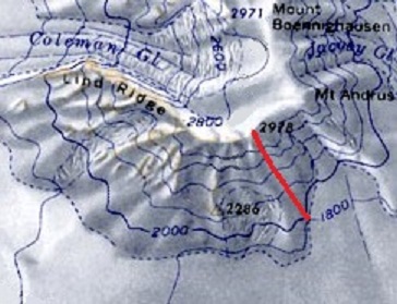
English: Contour map with an example fall line. Contour lines of constant elevation are blue, and one example fall line is red. |
| 日期 | |
| 來源 | 自己的作品 |
| 作者 | LithiumFlash (This image was created by modifying File:AmesRangeMap.jpg. The original image is in the public domain in the United States because it only contains materials that originally came from the United States Geological Survey, an agency of the United States Department of the Interior. For more information, see the official USGS copyright policy). |
授權條款
我,本作品的著作權持有者,決定用以下授權條款發佈本作品:
此檔案採用創用CC 姓名標示-相同方式分享 4.0 國際授權條款。
- 您可以自由:
- 分享 – 複製、發佈和傳播本作品
- 重新修改 – 創作演繹作品
- 惟需遵照下列條件:
- 姓名標示 – 您必須指名出正確的製作者,和提供授權條款的連結,以及表示是否有對內容上做出變更。您可以用任何合理的方式來行動,但不得以任何方式表明授權條款是對您許可或是由您所使用。
- 相同方式分享 – 如果您利用本素材進行再混合、轉換或創作,您必須基於如同原先的相同或兼容的條款,來分布您的貢獻成品。
檔案歷史
點選日期/時間以檢視該時間的檔案版本。
| 日期/時間 | 縮圖 | 尺寸 | 使用者 | 備註 | |
|---|---|---|---|---|---|
| 目前 | 2017年6月10日 (六) 04:26 | | 364 × 279(47 KB) | LithiumFlash | Slightly larger image, and removed some text on the map (map is arbitrary location). |
| 2017年6月8日 (四) 16:43 |  | 243 × 186(30 KB) | LithiumFlash | User created page with UploadWizard |
檔案用途
下列頁面有用到此檔案:
全域檔案使用狀況
以下其他 wiki 使用了這個檔案:
- de.wikipedia.org 的使用狀況
- en.wikipedia.org 的使用狀況
- es.wikibooks.org 的使用狀況
- fa.wikipedia.org 的使用狀況
- ja.wikipedia.org 的使用狀況