File:DC neighborhoods map.png

預覽大小:526 × 599 像素。 其他解析度:211 × 240 像素 | 421 × 480 像素 | 674 × 768 像素 | 899 × 1,024 像素 | 1,493 × 1,700 像素。
原始檔案 (1,493 × 1,700 像素,檔案大小:1.52 MB,MIME 類型:image/png)
摘要
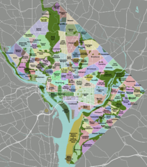
| 描述 | DC neighborhoods map |
| 日期 | |
| 來源 | self-made, tracing done from PD satellite imagery |
| 作者 | Peter Fitzgerald |
| 授權許可 (重用此檔案) |
CC-by 3.0 |
| 其他版本 | SVG available on Wikitravel Shared, although it is not the current version, as Shared has a 8MB filesize limit... |
|
Need a higher resolution version? There's one available at File:DC neighborhoods map high res.png. (The thumbnail does not display images at such a high resolution—to access the file, click the "Full resolution" link [1] below the broken thumbnail.) |
![[1]](https://upload.wikimedia.org/wikipedia/commons/b/b8/DC_neighborhoods_map_high_res.png)
授權條款
我,本作品的著作權持有者,決定用以下授權條款發佈本作品:
此檔案採用創用CC 姓名標示 3.0 未在地化版本授權條款。
- 您可以自由:
- 分享 – 複製、發佈和傳播本作品
- 重新修改 – 創作演繹作品
- 惟需遵照下列條件:
- 姓名標示 – 您必須指名出正確的製作者,和提供授權條款的連結,以及表示是否有對內容上做出變更。您可以用任何合理的方式來行動,但不得以任何方式表明授權條款是對您許可或是由您所使用。

|
本圖片是以PNG、GIF或JPEG格式上傳。然而,其中包含的資料或訊息,應該重新建立成可縮放向量圖形(SVG)檔案,以更有效率或更準確的方式儲存。如有可能,請上傳本圖片的SVG格式版本。在上傳之後,請修改維基各姊妹計畫中所有使用舊版圖片的條目(列在圖像連結章節中),替換為新版圖片,並在舊圖片的描述頁中加入{{Vector version available|新圖片名稱.svg}}模板,同時移除本模板。
|
檔案歷史
點選日期/時間以檢視該時間的檔案版本。
| 日期/時間 | 縮圖 | 尺寸 | 使用者 | 備註 | |
|---|---|---|---|---|---|
| 目前 | 2011年9月2日 (五) 02:21 | | 1,493 × 1,700(1.52 MB) | Peterfitzgerald | minor change |
| 2011年9月2日 (五) 02:15 |  | 1,493 × 1,700(1.52 MB) | Peterfitzgerald | Lots of corrections and refinements | |
| 2010年1月4日 (一) 20:53 |  | 1,493 × 1,700(1.5 MB) | Peterfitzgerald | split off Kalorama Triangle from Adams Morgan, adjusted Fairlawn & Randall Heights boundaries, & split off Spring Valley from American University Park | |
| 2009年1月30日 (五) 21:45 |  | 1,493 × 1,700(1.53 MB) | Peterfitzgerald | too high res, it would seem | |
| 2009年1月30日 (五) 21:39 |  | 4,390 × 5,000(5.66 MB) | Peterfitzgerald | increase resolution | |
| 2008年9月4日 (四) 14:32 |  | 1,493 × 1,700(1.53 MB) | Peterfitzgerald | increase font size for better in-article readability | |
| 2008年4月21日 (一) 02:33 |  | 1,493 × 1,700(1.43 MB) | Peterfitzgerald | a few fixes | |
| 2008年4月14日 (一) 17:10 |  | 1,493 × 1,700(1.46 MB) | Peterfitzgerald | Separate Burleith from Georgetown | |
| 2008年2月23日 (六) 02:37 |  | 1,493 × 1,700(1.41 MB) | Peterfitzgerald | {{Information |Description=DC neighborhoods map |Source=self-made, tracing done from PD satellite imagery |Date=22 February 2008 |Author= Peter Fitzgerald |Permission=CC-by-SA 3.0 |other_versions=SVG available on [http://wikitrave |
檔案用途
沒有使用此檔案的頁面。
全域檔案使用狀況
以下其他 wiki 使用了這個檔案:
- de.wikipedia.org 的使用狀況
- en.wikipedia.org 的使用狀況
- en.wikivoyage.org 的使用狀況
- et.wikipedia.org 的使用狀況
- frr.wikipedia.org 的使用狀況
- ur.wikipedia.org 的使用狀況
- vi.wikipedia.org 的使用狀況