File:Dao Niger and Harmakhis Vallis PIA02810.jpg

預覽大小:800 × 519 像素。 其他解析度:320 × 208 像素 | 640 × 415 像素 | 1,024 × 664 像素 | 1,280 × 830 像素 | 1,637 × 1,062 像素。
原始檔案 (1,637 × 1,062 像素,檔案大小:168 KB,MIME 類型:image/jpeg)
摘要
| 描述 |
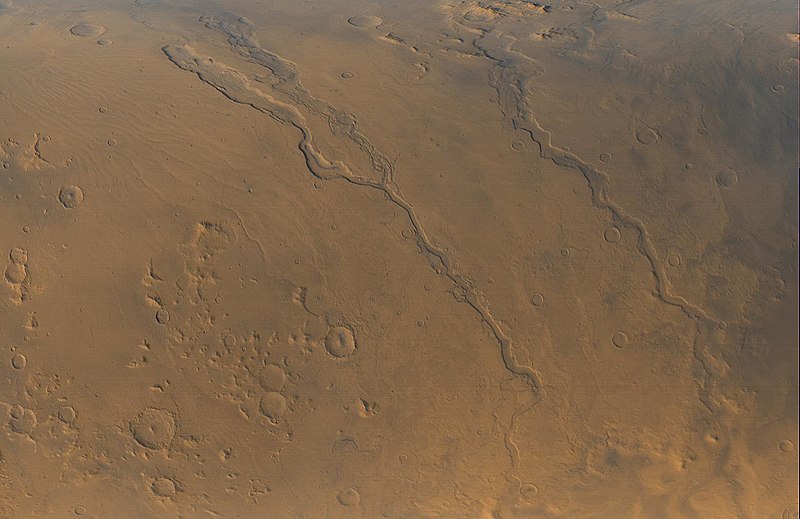
English: The Mars Global Surveyor (MGS) Mars Orbiter Camera (MOC) opened its fourth year orbiting the red planet with this mid-autumn view of three major valley systems east of the Hellas plains. From left to right, the first major valley, Dao Vallis, runs diagonally from the upper left to just past the lower center of the image. Niger Vallis joins Dao Vallis just above the center of the frame. Harmakhis Vallis extends diagonally across the right half of the picture, toward the lower right. These valleys are believed by some to have been formed--at least in part--by large outbursts of liquid water some time far back in the martian past, though there is no way to know exactly how many hundreds of millions or billions of years ago this might have occurred. In each valley, water would have flowed toward the bottom of the image. Although their dimensions vary along their courses, the valleys are all roughly 1 km (0.6 miles) deep and range in width from about 40 km (25 miles) down to about 8 km (5 mi). Located around 40°S, 270°W, the picture covers an area approximately 800 km across and is illuminated by sunlight from the lower left. North is toward the left; the picture is a composite of red and blue wide angle images obtained by MOC on September 13, 2000, |
| 來源 | http://photojournal.jpl.nasa.gov/catalog/PIA02810 |
| 作者 | NASA/JPL/MSSS |
授權條款
| 本作品由NASA創作,屬於公有領域。根據NASA的版權政策:“NASA的創作除非另有聲明否則不受版權保護。”(參見:Template:PD-USGov/zh,NASA版權政策或JPL圖像使用政策) | ||
 |
警告:
|
檔案歷史
點選日期/時間以檢視該時間的檔案版本。
| 日期/時間 | 縮圖 | 尺寸 | 使用者 | 備註 | |
|---|---|---|---|---|---|
| 目前 | 2008年4月12日 (六) 06:55 | | 1,637 × 1,062(168 KB) | Bryan Derksen | {{Information |Description={{en| The Mars Global Surveyor (MGS) Mars Orbiter Camera (MOC) opened its fourth year orbiting the red planet with this mid-autumn view of three major valley systems east of the Hellas plains. From left to right, the first ma |
檔案用途
全域檔案使用狀況
以下其他 wiki 使用了這個檔案:
- ca.wikipedia.org 的使用狀況
- cs.wikipedia.org 的使用狀況
- en.wikipedia.org 的使用狀況
- es.wikipedia.org 的使用狀況
- fr.wikipedia.org 的使用狀況
- it.wikipedia.org 的使用狀況
- ja.wikipedia.org 的使用狀況
- pl.wikipedia.org 的使用狀況
- pt.wikipedia.org 的使用狀況
- uk.wikipedia.org 的使用狀況
- www.wikidata.org 的使用狀況