File:Districts of the Ashanti Region (2012).svg

此 SVG 檔案的 PNG 預覽的大小:744 × 524 像素。 其他解析度:320 × 225 像素 | 640 × 451 像素 | 1,024 × 721 像素 | 1,280 × 902 像素 | 2,560 × 1,803 像素。
原始檔案 (SVG 檔案,表面大小:744 × 524 像素,檔案大小:3.97 MB)
.svg?uselang=zh-tw)
.svg?uselang=zh-tw)
.svg?action=history&uselang=zh-tw)
.svg)
摘要
| 描述 |
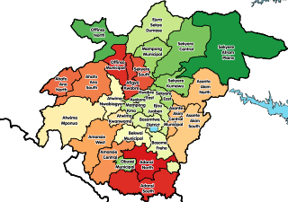
English: Map showing all 30 districts of the Ashanti Region of Ghana, including the new districts that were created in 2012. |
| 日期 | |
| 來源 | 自己的作品 |
| 作者 | Macabe5387 |
| SVG開發 |
授權條款
我,本作品的著作權持有者,決定用以下授權條款發佈本作品:
此檔案採用創用CC 姓名標示-相同方式分享 4.0 國際授權條款。
- 您可以自由:
- 分享 – 複製、發佈和傳播本作品
- 重新修改 – 創作演繹作品
- 惟需遵照下列條件:
- 姓名標示 – 您必須指名出正確的製作者,和提供授權條款的連結,以及表示是否有對內容上做出變更。您可以用任何合理的方式來行動,但不得以任何方式表明授權條款是對您許可或是由您所使用。
- 相同方式分享 – 如果您利用本素材進行再混合、轉換或創作,您必須基於如同原先的相同或兼容的條款,來分布您的貢獻成品。
檔案歷史
點選日期/時間以檢視該時間的檔案版本。
| 日期/時間 | 縮圖 | 尺寸 | 使用者 | 備註 | |
|---|---|---|---|---|---|
| 目前 | 2017年12月29日 (五) 14:43 | | 744 × 524(3.97 MB) | Macabe5387 | Some district names were incorrect in the previous version. |
| 2017年12月29日 (五) 12:40 |  | 744 × 524(4.08 MB) | Macabe5387 | User created page with UploadWizard |
檔案用途
下列24個頁面有用到此檔案:
全域檔案使用狀況
以下其他 wiki 使用了這個檔案:
- ar.wikipedia.org 的使用狀況
- be.wikipedia.org 的使用狀況
- ca.wikipedia.org 的使用狀況
- ceb.wikipedia.org 的使用狀況
- de.wikipedia.org 的使用狀況
- dga.wikipedia.org 的使用狀況
- en.wikipedia.org 的使用狀況
- Districts of Ghana
- Ashanti Region
- Obuasi
- Tepa, Ghana
- Manso Nkwanta
- Ejura
- Sekyere South District
- Ahafo Ano North Municipal District
- Ahafo Ano South District
- Bekwai Municipal Assembly
- Amansie West District
- Asante Akim South Municipal District
- Atwima District
- Ejisu-Juaben Municipal District
- Ejura Sekyedumase Municipal District
- Kumasi Metropolitan Assembly
- Kwabre District
- Offinso Municipal District
- Sekyere East District
- Mampong Municipal District
- Adansi North District
- Adansi South District
- Amansie Central District
- Atwima Mponua District
- Bosomtwe District
- Obuasi Municipal Assembly
- Atwima Nwabiagya Municipal District
- Ejisu
- Template:Districts of the Ashanti Region
- Administrative divisions of Ghana
- Agogo, Ghana
- Mampong
- Konongo, Ghana
- Nsuta
- Asante Akim North District
- Sekyere West District
- Asante people
- Afigya Kwabre District
- Atwima Kwanwoma District
- Bosome Freho District
- Sekyere Central District
- Offinso North District
- Sekyere Afram Plains District
檢視此檔案的更多全域使用狀況。
.svg)
.svg)