File:Galapagos Islands topographic map-fr.png

預覽大小:600 × 600 像素。 其他解析度:240 × 240 像素 | 480 × 480 像素 | 768 × 768 像素 | 1,024 × 1,024 像素 | 2,160 × 2,160 像素。
原始檔案 (2,160 × 2,160 像素,檔案大小:2.14 MB,MIME 類型:image/png)
摘要
| 拍攝地點 | | 位於此地的本圖片與其他圖片: OpenStreetMap |
|---|
| 描述 |
|
||
| 日期 | |||
| 來源 |
Own work
|
||
| 作者 | Eric Gaba (Sting - fr:Sting) | ||
| 授權許可 (重用此檔案) |
|
||
| 其他版本 |
[]
|

.png)


授權條款
我,本作品的著作權持有者,決定用以下授權條款發佈本作品:

|
已授權您依據自由軟體基金會發行的無固定段落、封面文字和封底文字GNU自由文件授權條款1.2版或任意後續版本,對本檔進行複製、傳播和/或修改。該協議的副本列在GNU自由文件授權條款中。 |
This file is licensed under the Creative Commons Attribution-Share Alike Attribution-Share Alike 4.0 International, 3.0 Unported, 2.5 Generic, 2.0 Generic and 1.0 Generic license.
- 您可以自由:
- 分享 – 複製、發佈和傳播本作品
- 重新修改 – 創作演繹作品
- 惟需遵照下列條件:
- 姓名標示 – 您必須指名出正確的製作者,和提供授權條款的連結,以及表示是否有對內容上做出變更。您可以用任何合理的方式來行動,但不得以任何方式表明授權條款是對您許可或是由您所使用。
- 相同方式分享 – 如果您利用本素材進行再混合、轉換或創作,您必須基於如同原先的相同或兼容的條款,來分布您的貢獻成品。
您可以選擇您需要的授權條款。
檔案歷史
點選日期/時間以檢視該時間的檔案版本。
| 日期/時間 | 縮圖 | 尺寸 | 使用者 | 備註 | |
|---|---|---|---|---|---|
| 目前 | 2010年7月20日 (二) 00:34 | | 2,160 × 2,160(2.14 MB) | Sting | Reverted to version as of 14:35, 19 July 2010 : test ended |
| 2010年7月20日 (二) 00:28 |  | 2,160 × 2,160(4.3 MB) | Sting | sRGB converted (just for test) | |
| 2010年7月19日 (一) 14:35 |  | 2,160 × 2,160(2.14 MB) | Sting | Color profile | |
| 2009年11月17日 (二) 14:37 |  | 2,160 × 2,160(2.14 MB) | Sting | Embedded sRGB profile | |
| 2008年11月3日 (一) 12:52 |  | 2,160 × 2,160(2.06 MB) | Sting | Corrections | |
| 2008年7月5日 (六) 01:35 |  | 2,160 × 2,160(2.06 MB) | Sting | Oups ! | |
| 2008年7月5日 (六) 01:19 |  | 2,160 × 2,160(2.07 MB) | Sting | Several little improvements | |
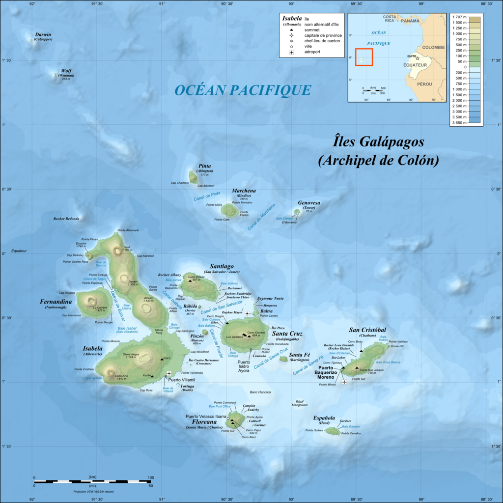
| 2008年7月3日 (四) 02:17 |  | 2,160 × 2,160(1.87 MB) | Sting | == Summary == {{Location|00|30|00|S|90|30|00|W|scale:1000000}} <br/>{{Information |Description={{en|Topographic and bathymetric map of the Galápagos Islands, Ecuador.}} {{fr|Carte topographique et bathymétrique |
檔案用途
沒有使用此檔案的頁面。
全域檔案使用狀況
以下其他 wiki 使用了這個檔案:
- en.wikipedia.org 的使用狀況
- fr.wikipedia.org 的使用狀況
- fr.wiktionary.org 的使用狀況
- hu.wikipedia.org 的使用狀況