File:Kansas City Southern Railway system map.svg

此 SVG 檔案的 PNG 預覽的大小:800 × 457 像素。 其他解析度:320 × 183 像素 | 640 × 366 像素 | 1,024 × 585 像素 | 1,280 × 731 像素 | 2,560 × 1,463 像素 | 1,400 × 800 像素。
原始檔案 (SVG 檔案,表面大小:1,400 × 800 像素,檔案大小:543 KB)
摘要
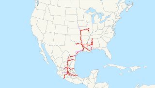
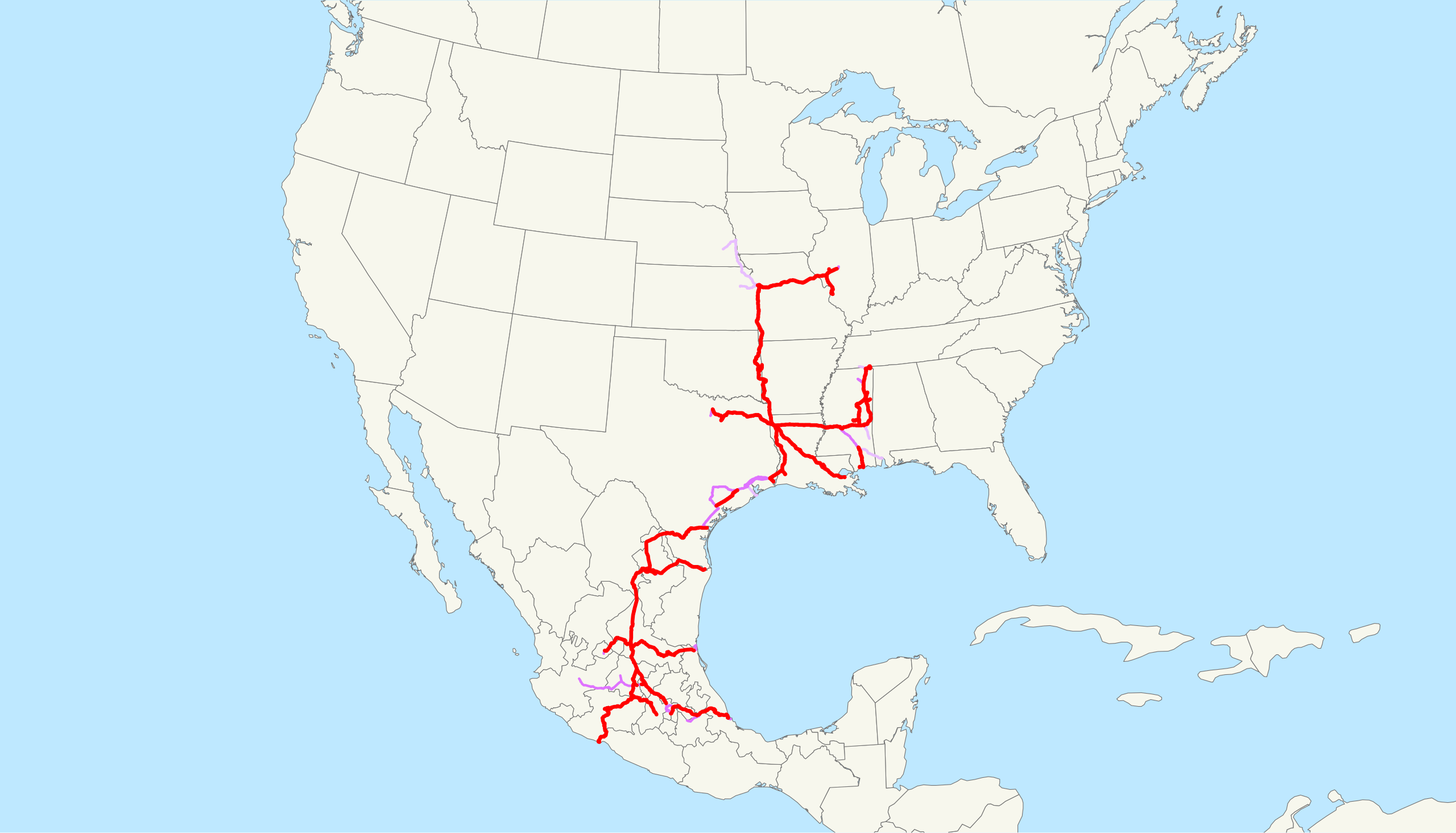
| 描述 | This is a map of the Kansas City Southern Railway as of 2009, with trackage rights in purple (haulage rights are lighter). Email me if you would like a copy of the GIS data I created (modified from Bureau of Transportation Statistics North American Transportation Atlas Data) or if you see any errors. |
| 日期 | 2009年2月20日 (原始上傳日期) |
| 來源 | 无法识别来源。根据版权声明推断为其自己的作品。 |
| 作者 | 无法识别作者。根据版权声明推断作者为NE2。 |
授權條款
| 我,此作品的版權所有人,釋出此作品至公共領域。此授權條款在全世界均適用。 這可能在某些國家不合法,如果是的話: 我授予任何人有權利使用此作品於任何用途,除受法律約束外,不受任何限制。 |
檔案歷史
點選日期/時間以檢視該時間的檔案版本。
| 日期/時間 | 縮圖 | 尺寸 | 使用者 | 備註 | |
|---|---|---|---|---|---|
| 目前 | 2009年2月23日 (一) 13:09 | | 1,400 × 800(543 KB) | NE2 | Changed the display of lines owned by the government for the purposes of passenger rail, so that if KCS is the primary freight operator it is not shown as trackage rights. |
| 2009年2月20日 (五) 04:30 |  | 1,400 × 800(542 KB) | NE2 | == Summary == This is a map of the Kansas City Southern Railway as of 2009, with trackage rights in purple (haulage rights are lighter). Email me if you would like a copy of the GIS dat |
檔案用途
下列頁面有用到此檔案:
全域檔案使用狀況
以下其他 wiki 使用了這個檔案:
- de.wikipedia.org 的使用狀況
- en.wikipedia.org 的使用狀況
- es.wikipedia.org 的使用狀況
- fr.wikipedia.org 的使用狀況
- hu.wikipedia.org 的使用狀況
- id.wikipedia.org 的使用狀況
- it.wikipedia.org 的使用狀況
- ja.wikipedia.org 的使用狀況
- ko.wikipedia.org 的使用狀況
- nl.wikipedia.org 的使用狀況
- pt.wikipedia.org 的使用狀況
- www.wikidata.org 的使用狀況