File:Lake tana.jpg
預覽大小:614 × 600 像素。 其他解析度:246 × 240 像素 | 639 × 624 像素。
原始檔案 (639 × 624 像素,檔案大小:166 KB,MIME 類型:image/jpeg)
摘要
| 描述 |
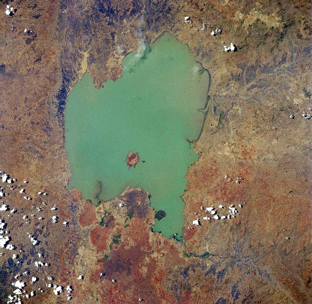
English: Lake Tana, Ethiopia - April 1991. Low-oblique, west-looking photograph (now after 270 degree rotation north-looking). Located in the central highlands of Ethiopia, Lake Tana, the country’s largest lake, covers 1400 square miles (3625 square kilometers). The lake is 47 miles (76 kilometers) long and 44 miles (71 kilometers) wide and sits at an elevation of 6000 feet (1830 meters) above sea level.
Ελληνικά: Δορυφορική φωτογραφία της Λίμνης Τάνα στην Αιθιοπία |
| 日期 | |
| 來源 | Image Science and Analysis Laboratory, NASA-Johnson Space Center, The Gateway to Astronaut Photography of Earth: STS037-84-3 |
| 作者 | NASA |
授權條款
| 本作品由NASA創作,屬於公有領域。根據NASA的版權政策:“NASA的創作除非另有聲明否則不受版權保護。”(參見:Template:PD-USGov/zh,NASA版權政策或JPL圖像使用政策) | ||
 |
警告:
|
檔案歷史
點選日期/時間以檢視該時間的檔案版本。
| 日期/時間 | 縮圖 | 尺寸 | 使用者 | 備註 | |
|---|---|---|---|---|---|
| 目前 | 2012年12月3日 (一) 07:45 | | 639 × 624(166 KB) | Rotatebot | Bot: Image rotated by 270° |
| 2005年8月13日 (六) 01:49 |  | 639 × 639(150 KB) | Boticario | Lake Tana, Ethiopia - April 1991 image description [http://eol.jsc.nasa.gov/sseop/EFS/photoinfo.pl?PHOTO=STS037-84-3 here] {{PD-USGov-NASA}} |
檔案用途
下列頁面有用到此檔案:
全域檔案使用狀況
以下其他 wiki 使用了這個檔案:
- af.wikipedia.org 的使用狀況
- ar.wikipedia.org 的使用狀況
- azb.wikipedia.org 的使用狀況
- az.wikipedia.org 的使用狀況
- bn.wikipedia.org 的使用狀況
- br.wikipedia.org 的使用狀況
- ca.wikipedia.org 的使用狀況
- ceb.wikipedia.org 的使用狀況
- cs.wikipedia.org 的使用狀況
- da.wikipedia.org 的使用狀況
- de.wikipedia.org 的使用狀況
- el.wikipedia.org 的使用狀況
- en.wikipedia.org 的使用狀況
- eo.wikipedia.org 的使用狀況
- es.wikipedia.org 的使用狀況
- fa.wikipedia.org 的使用狀況
- fi.wikipedia.org 的使用狀況
- fr.wikipedia.org 的使用狀況
- gl.wikipedia.org 的使用狀況
- he.wikipedia.org 的使用狀況
- hr.wikipedia.org 的使用狀況
- hu.wikipedia.org 的使用狀況
- id.wikipedia.org 的使用狀況
- is.wikipedia.org 的使用狀況
- it.wikipedia.org 的使用狀況
- ja.wikipedia.org 的使用狀況
- ka.wikipedia.org 的使用狀況
- kn.wikipedia.org 的使用狀況
- ko.wikipedia.org 的使用狀況
- ky.wikipedia.org 的使用狀況
- la.wikipedia.org 的使用狀況
- lv.wikipedia.org 的使用狀況
- mk.wikipedia.org 的使用狀況
- ml.wikipedia.org 的使用狀況
- my.wikipedia.org 的使用狀況
- nl.wikipedia.org 的使用狀況
- no.wikipedia.org 的使用狀況
- oc.wikipedia.org 的使用狀況
- pnb.wikipedia.org 的使用狀況
- pt.wikipedia.org 的使用狀況
- ro.wikipedia.org 的使用狀況
- sh.wikipedia.org 的使用狀況
- sl.wikipedia.org 的使用狀況
- sr.wikipedia.org 的使用狀況
檢視此檔案的更多全域使用狀況。