File:MountAkutan.jpg

預覽大小:800 × 538 像素。 其他解析度:320 × 215 像素 | 640 × 430 像素 | 1,024 × 688 像素。
原始檔案 (1,024 × 688 像素,檔案大小:247 KB,MIME 類型:image/jpeg)
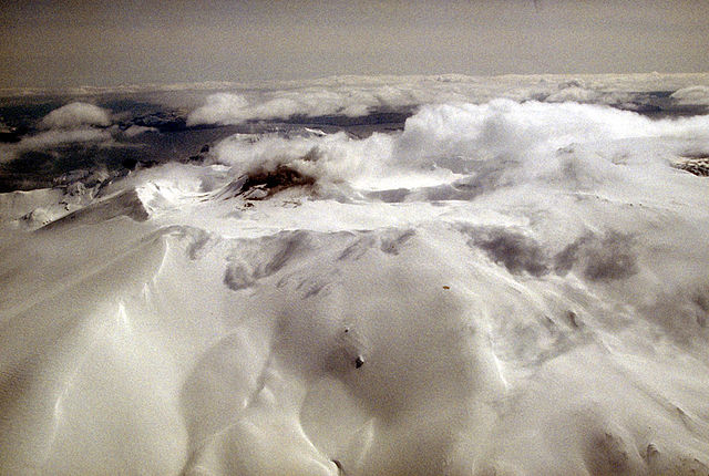
Aerial view of Akutan volcano that forms the west part of Akutan Island in the eastern Aleutian Islands. The volcano's summit is truncated by a 2-km-wide (1.2 mi) caldera that contains a cinder cone that has been the site of frequent historical eruptions. View is to the southeast.
Photograph by C. Nye, Alaska Division of Geological and Geophysical Surveys, May 10, 1994. Source: http://geopubs.wr.usgs.gov/dds/dds-40/
|
|
檔案歷史
點選日期/時間以檢視該時間的檔案版本。
| 日期/時間 | 縮圖 | 尺寸 | 使用者 | 備註 | |
|---|---|---|---|---|---|
| 目前 | 2005年1月28日 (五) 12:55 | | 1,024 × 688(247 KB) | GarciaB~commonswiki | Mount Akutan, Alaska |
檔案用途
下列頁面有用到此檔案:
全域檔案使用狀況
以下其他 wiki 使用了這個檔案:
- ca.wikipedia.org 的使用狀況
- ceb.wikipedia.org 的使用狀況
- cs.wikipedia.org 的使用狀況
- de.wikipedia.org 的使用狀況
- en.wikipedia.org 的使用狀況
- es.wikipedia.org 的使用狀況
- eu.wikipedia.org 的使用狀況
- fi.wikipedia.org 的使用狀況
- ga.wikipedia.org 的使用狀況
- gv.wikipedia.org 的使用狀況
- hy.wikipedia.org 的使用狀況
- it.wikipedia.org 的使用狀況
- ms.wikipedia.org 的使用狀況
- nl.wikipedia.org 的使用狀況
- no.wikipedia.org 的使用狀況
- uk.wikipedia.org 的使用狀況
- ur.wikipedia.org 的使用狀況
- www.wikidata.org 的使用狀況