File:NIT Combined Flights Ground Measurements 30Mar 03Apr2011 results.jpg

預覽大小:800 × 555 像素。 其他解析度:320 × 222 像素 | 640 × 444 像素 | 1,024 × 710 像素 | 1,245 × 863 像素。
原始檔案 (1,245 × 863 像素,檔案大小:612 KB,MIME 類型:image/jpeg)
摘要
| 描述 |
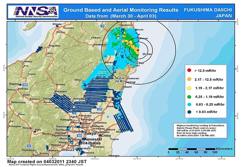
English: Combined results of 211 flight hours of aerial monitoring operations and ground measurements made by DOE, DoD and Japanese monitoring teams. |
| 日期 | |
| 來源 | 4th slide of http://energy.gov/news/documents/AMS_Data_April_4__v1.pptx available at http://blog.energy.gov/content/situation-japan |
| 作者 | National Nuclear Security Administration (NNSA) US Department of Energy |
| 其他版本 |
|


授權條款
| 此圖像是美國能源部(或前身組織)的僱員於其公務中所作之作品。由於此作品由美國聯邦政府所作,其處於公有領域。
請注意美國國家實驗室使用不同授權條款而其中部分為自由條款。檢查實驗室的網站政策後才可使用此標籤。
|

|
檔案歷史
點選日期/時間以檢視該時間的檔案版本。
| 日期/時間 | 縮圖 | 尺寸 | 使用者 | 備註 | |
|---|---|---|---|---|---|
| 目前 | 2011年4月9日 (六) 09:36 | | 1,245 × 863(612 KB) | Teofilo | cropped |
| 2011年4月9日 (六) 09:26 |  | 1,920 × 1,080(689 KB) | Teofilo | {{Information |Description ={{en|1=Combined results of 211 flight hours of aerial monitoring operations and ground measurements made by DOE, DoD and Japanese monitoring teams.}} |Source =4th slide of http://energy.gov/news/documents/AMS_Data_Ap |
檔案用途
下列4個頁面有用到此檔案:
全域檔案使用狀況
以下其他 wiki 使用了這個檔案:
- bg.wikipedia.org 的使用狀況
- de.wikipedia.org 的使用狀況
- en.wikipedia.org 的使用狀況
- en.wikibooks.org 的使用狀況
- es.wikipedia.org 的使用狀況
- it.wikipedia.org 的使用狀況
- ja.wikipedia.org 的使用狀況
- pl.wikipedia.org 的使用狀況
- pt.wikipedia.org 的使用狀況
- so.wikipedia.org 的使用狀況
- sr.wikinews.org 的使用狀況
- th.wikipedia.org 的使用狀況
- www.wikidata.org 的使用狀況