File:Switzerland (14399363612).jpg
原始檔案 (3,032 × 1,998 像素,檔案大小:1.53 MB,MIME 類型:image/jpeg)
.jpg?uselang=zh-tw)
.jpg?uselang=zh-tw)
.jpg?action=history&uselang=zh-tw)
.jpg)
摘要
| 描述 |
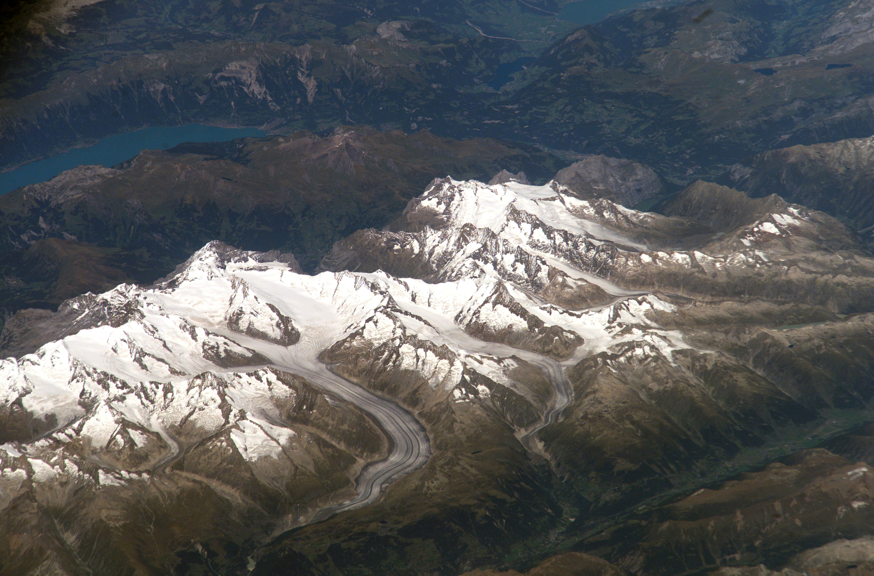
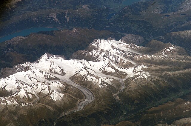
Bernese Alps, Switzerland Bernese Alps, Switzerland is featured in this image photographed by an Expedition 13 crewmember onboard the International Space Station. The formidable mountain system of the Alps stretches across much of central Europe, with seven countries claiming portions of the mountains within their borders (Germany, France, Switzerland, Italy, Liechtenstein, Austria, and Slovenia). The glacial landscape of the Bernese Alps, located in southwestern Switzerland, is well illustrated by this view. The image was taken by a crewmember looking north-northwest while the station was located over the Mediterranean Sea between Corsica and Italy -- this oblique viewing angle imparts a sense of perspective to the image. This type of viewing angle complements more nadir (downward)--viewing imagery of the region. Three of the higher peaks of the central Alps are visible--Jungfrau (4,158 meters), Moench (4,089 meters), and Eiger (3,970 meters). To the east and south of the Jungfrau is the Aletsch Glacier, clearly marked by dark medial moraines extending along the glacier's length parallel to the valley axis. The moraines are formed from rock and soil debris collected along the sides of three mountain glaciers located near the Jungfrau and Moench peaks -- as these flowing ice masses merge to form the Aletsch Glacier, the debris accumulates in the middle of the glacier and is carried along the flow direction. According to geologists, Lake Brienz to the northwest was formed by the actions of both glacial ice and the flowing waters of the Aare and Lutschine rivers, and has a maximum depth of 261 meters. The lake has a particularly fragile ecosystem, as demonstrated by the almost total collapse of the whitefish population in 1999. Possible causes for the collapse, according to the scientists, include increased water turbidity associated with upstream hydropower plant operations, and reduction of phosphorus (a key nutrient for lake algae, a basic element of the local food web) due to water quality concerns. Credit: NASA/ISS NASA Goddard Space Flight Center enables NASA’s mission through four scientific endeavors: Earth Science, Heliophysics, Solar System Exploration, and Astrophysics. Goddard plays a leading role in NASA’s accomplishments by contributing compelling scientific knowledge to advance the Agency’s mission. Follow us on Twitter Like us on Facebook Find us on Instagram |
| 日期 | |
| 來源 | Switzerland |
| 作者 | NASA Goddard Space Flight Center from Greenbelt, MD, USA |
授權條款
- 您可以自由:
- 分享 – 複製、發佈和傳播本作品
- 重新修改 – 創作演繹作品
- 惟需遵照下列條件:
- 姓名標示 – 您必須指名出正確的製作者,和提供授權條款的連結,以及表示是否有對內容上做出變更。您可以用任何合理的方式來行動,但不得以任何方式表明授權條款是對您許可或是由您所使用。
| 這幅圖片原始出處為Flickr的https://flickr.com/photos/24662369@N07/14399363612 ,作者為NASA Goddard Photo and Video 。經機器人FlickreviewR在2016年9月17日審查後確定為採用cc-by-2.0的協議授權使用。 |
| 本作品由NASA創作,屬於公有領域。根據NASA的版權政策:“NASA的創作除非另有聲明否則不受版權保護。”(參見:Template:PD-USGov/zh,NASA版權政策或JPL圖像使用政策) | ||
 |
警告:
|
檔案歷史
點選日期/時間以檢視該時間的檔案版本。
| 日期/時間 | 縮圖 | 尺寸 | 使用者 | 備註 | |
|---|---|---|---|---|---|
| 目前 | 2016年9月17日 (六) 20:33 | | 3,032 × 1,998(1.53 MB) | Vanished Account Byeznhpyxeuztibuo | Transferred from Flickr via Flickr2Commons |
檔案用途
下列頁面有用到此檔案:
全域檔案使用狀況
以下其他 wiki 使用了這個檔案:
- ca.wikipedia.org 的使用狀況
- en.wikipedia.org 的使用狀況
- he.wikipedia.org 的使用狀況
- ja.wikipedia.org 的使用狀況
- ko.wikipedia.org 的使用狀況
- ru.wikipedia.org 的使用狀況
- sl.wikipedia.org 的使用狀況
- uk.wikipedia.org 的使用狀況
.jpg)