示巴高地
示巴高地(Terra Sabaea)是火星上一处幅员辽阔的大区域,最宽处达到4700 公里(2900英里),其中心坐标位于2°N 42°E / 2°N 42°E坐标:2°N 42°E / 2°N 42°E处,其名称自火星上一处经典反照率特征,1979年,被国际天文联合会正式批准接受。沙巴高地相当大,部分横跨了阿拉伯区、大瑟提斯区、雅庇吉亚区、伊斯墨诺斯湖区和示巴湾区等五大区域。

冰川 编辑
有些景观看上去就像地球上从山谷中流出的冰川,部分呈现出空荡荡的外观,就像所有的冰都已消失,只剩下了冰碛—冰川携带的泥土和碎屑。由于大部分冰已消失,使得中间被掏空[1]。这些假想的高山冰川被称为类冰川形态(GLF)或类冰川流(GLF)[2]。类冰川形态是一条出现较晚的术语,可能更准确,因为无法确定该结构目前是否还在移动[3] 。有时在文献中看到的另一条更通用的术语称之为粘性流特征[3]。
表面上的各种其他特征也被解释为与流动冰直接相关,例如锐蚀地形[4]、线状谷底沉积[5][6]、同心坑沉积[7][8] 以及皱岭等[9],在中纬度和极地区图像中看到的各种表面纹理也被认为与冰川中的冰升华有关[8][10]。
下面的图片显示了一些被认为是冰川的特征,其中有一些可能仍含有冰,而在其他地区,冰可能已基本消失了。由于在仅数米厚的碎屑下就可能有水冰,因此,这些地方可为未来定居者提供水源。
-
 陆地卫星8号显示的地球北极圈象脚冰川的罗默湖(Romer Lake),该照片显示的数条冰川,其形状与火星上许多被认为也是冰川的地貌相同。
 -
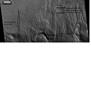
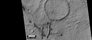
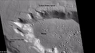
 背景相机拍摄的伊斯墨诺斯湖区被数处冰川侵蚀的桌山。在接下来的两幅高分辨率成像科学设备照片中,可更详细地观看到其中的冰川。
 -

-
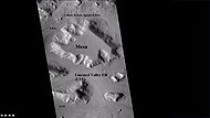
 放大的前一幅图像矩形区,在地球上,这种山脊被称为高山冰川尾碛。
 -
-
-
 HiWish计划下高分辨率成像科学设备显示的线状谷底沉积(LVF)特写,注:这是先前背景相机图像的放大版。


-
-

-
 HiWish计划下高分辨率成像科学设备显示的伊斯墨诺斯湖区线状谷底沉积彩色近景图。


沙丘 编辑
当有稳定的风向和足够多的沙子时,就会产生出完美的沙丘条件,形成一座新月沙丘。新月沙丘的迎风侧一般为缓坡,而背风侧则是更陡峭的斜坡,那里经常会形成沙堆角或凹口[11],整片沙丘似乎随风而动。观察火星上的沙丘可告诉我们那里的风向及风力强度。如果定期拍摄照片,则可能会看到沙丘的变化或沙丘表面的涟漪。火星上的沙丘通常呈深色,因为它们是由普通的火山玄武岩所形成。在干燥环境下,玄武岩中的深色矿物,如橄榄石和辉石,不会像在地球上那样会分解。虽然不常见,但在夏威夷也发现了一些黑色的沙子,那里也有许多火山都喷出玄武岩。新月沙丘是一条俄罗斯术语,因为这种类型的沙丘最早出现在突厥斯坦的沙漠地区[12]。火星上的一些风是在春季两极干冰被加热时产生的,那时固态的二氧化碳(干冰)升华或直接变成气体并高速冲走。 火星每年大气层中有30% 的二氧化碳会冻结并覆盖在处于冬季的极地,因此极有可能出现强风[13]。在示巴高地部分地区出现的沙丘如下图所示。
-
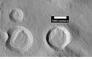
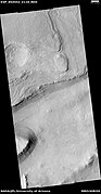
 HiWish计划下高分辨率成像科学设备显示的舍贝勒陨击坑中的沙丘。
 -
 HiWish计划下高分辨率成像科学设备显示的沙丘和陨石坑,有些沙丘为新月形沙丘。


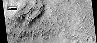
示巴高地的侵蚀特征 编辑
-
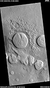
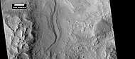
 火星轨道器相机公共目标计划下火星全球探勘者号拍摄的大瑟提斯区被侵蚀的桌山,要步行穿越这一特征是很困难的。
 -
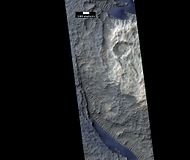
 HiWish计划下高分辨率成像科学设备拍摄的陨石坑沉积物特写照片,显示了撞击陨石坑和塌陷形成的深坑。


同心坑沉积 编辑
同心坑沉积是一种地貌,其中撞击坑内大部分地表都覆盖着大量的平行山脊 [14],一般在火星中纬度地区较为常见[15][16],普遍认为这是由冰川运动所引起[17][18]。
-

-
 HiWish计划下高分辨率成像科学设备显示的同心坑沉积发育良好的凹陷。
 -
 HiWish计划下高分辨率成像科学设备拍摄的含有同心坑沉积的陨坑特写照片,可看到坑内地表上分布有深坑的裂缝。


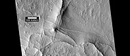
陨石坑中的岩层 编辑
斜坡上的岩层,尤其是陨石坑坡壁上的岩层,被认为是一种曾广泛分布的物质残迹,访物质大部分已经被侵蚀掉了[19]。
-
 HiWish计划下高分辨率成像科学设备显示的陨坑中的岩层,该区域可能被这些岩层覆盖,除陨坑内受保护的部分外,其余部分的岩层现在都已被侵蚀了。
 -
 HiWish计划下高分辨率成像科学设备显示的陨坑中的岩层。
 -
 HiWish计划下高分辨率成像科学设备显示的陨坑中的岩层。
 -
 HiWish计划下高分辨率成像科学设备显示的陨坑中各层近景,注:这是前一幅图像的放大版。


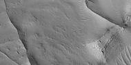
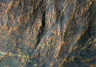
岩层 编辑
火星上的许多地方都有分层重叠的岩石,岩石可通过火山、风或水等多种作用方式形成岩层[20],地下水也可能参与了某些地方地层的形成。
-
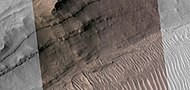
 HiWish计划下高分辨率成像科学设备显示的弗拉马利翁陨击坑中的岩层。
 -
 HiWish计划下高分辨率成像科学设备显示的岩层.


-
 HiWish计划下高分辨率成像科学设备显示的岩层宽景图
 -
 HiWish计划下高分辨率成像科学设备显示的岩层近景图
 -
 HiWish计划下高分辨率成像科学设备显示的岩层近景,一条突脊垂直穿过了岩层。
 -
 HiWish计划下高分辨率成像科学设备显示的岩层近景,图片部分彩色,一道突脊垂直穿过了各岩层。


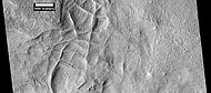
线性脊状网 编辑
线性脊状网在火星各地的陨石坑内外都能找到[21],这些突脊通常以格子状相交的直线形式出现,它们长数百米,高几十米,宽数米。据认为,撞击会在地表形成裂缝,这些裂缝后来又充当了流体通道,液体使这些结构胶结凝固。随着时间的推移,周围的材料被侵蚀掉,从而留下坚硬的突脊。 由于山脊出现在有粘土的地方,这些地层可以作为粘土的标志,而粘土的形成需要水[22][23][24],这里的水可能提供了支撑。
-
 HiWish计划高分辨率成像科学设备显示的脊状网,它们可以通过各种方式形成。
 -
 HiWish计划高分辨率成像科学设备显示的彩色脊线近景图。
 -
 HiWish计划高分辨率成像科学设备显示的与前两幅图像相同位置的更多脊线
 -
 HiWish计划高分辨率成像科学设备显示的线性脊状网。
 -
 HiWish计划高分辨率成像科学设备显示的前一幅线性脊状网图像的彩色特写。
 -
 HiWish计划高分辨率成像科学设备显示的与前两幅图像位于同一位置的更多线性脊状网。


-
 HiWish计划高分辨率成像科学设备显示的线性脊状网,该图像的部分区域将在后面的照片中被放大。
 -
 HiWish计划高分辨率成像科学设备显示的线性脊状网近景,这是前一幅图像的放大版。
 -
 CHiWish计划高分辨率成像科学设备显示的线性脊状网近景,这是先前图像的放大版,方框显示了足球场大小的区域。
 -
 HiWish计划高分辨率成像科学设备显示的线性脊状网近景,这是先前图像的放大版。
 -
 HiWish计划高分辨率成像科学设备显示的突脊近景,这是之前图像的放大版,图像中有一座显示出岩层的小桌山。
 -
 HiWish计划高分辨率成像科学设备显示的彩色线性脊状网近景,这是之前图像的放大版。


其它特征 编辑
-
-
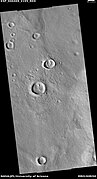
 背景相机拍摄的桌山宽景照片,显示了舌状岩屑坡(LDA)和线状谷底沉积(LVF)),据认为这两者都是被岩屑覆盖的冰川。
 -
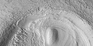
 HiWish计划高分辨率成像科学设备显示的脑纹地形。
 -
 上一张桌山背景相机中舌状岩屑坡的特写,图中显示了更常见的细胞开放型脑地形和细胞封闭型脑纹地形,开放型细胞被认为里面含有冰核。


-
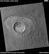 HiWish计划高分辨率成像科学设备显示的可能形成于富冰地面的撞击坑。
 -
 HiWish计划高分辨率成像科学设备观察到的可能形成于富冰地面上的撞击坑,请注意喷出物似乎比周边地貌更低。原因可能是热喷射物导致了一些冰的消失,从而降低了喷射物的水平面。


火星交互地图 编辑

另请查阅 编辑
参引文献 编辑
- ^ Milliken, R., J. Mustard, D. Goldsby. 2003. Viscous flow features on the surface of Mars: Observations from high-resolution Mars Orbiter Camera (MOC) images. J. Geophys. Res. 108. doi:10.1029/2002JE002005.
- ^ Arfstrom, J and W. Hartmann. 2005. Martian flow features, moraine-like ridges, and gullies: Terrestrial analogs and interrelationships. Icarus 174, 321-335.
- ^ 3.0 3.1 Hubbard B., R. Milliken, J. Kargel, A. Limaye, C. Souness. 2011. Geomorphological characterisation and interpretation of a mid-latitude glacier-like form: Hellas Planitia, Mars Icarus 211, 330–346
- ^ Lucchitta, Baerbel K. "Ice and debris in the fretted terrain, Mars." Journal of Geophysical Research: Solid Earth (1978–2012) 89.S02 (1984): B409-B418.
- ^ G.A. Morgan, J.W. Head, D.R. Marchant Lineated valley fill (LVF) and lobate debris aprons (LDA) in the Deuteronilus Mensae northern dichotomy boundary region, Mars: Constraints on the extent, age and episodicity of Amazonian glacial events Icarus, 202 (2009), pp. 22–38
- ^ D.M.H. Baker, J.W. Head, D.R. Marchant Flow patterns of lobate debris aprons and lineated valley fill north of Ismeniae Fossae, Mars: Evidence for extensive mid-latitude glaciation in the Late Amazonian Icarus, 207 (2010), pp. 186–209
- ^ Milliken, R. E., J. F. Mustard, and D. L. Goldsby. "Viscous flow features on the surface of Mars: Observations from high-resolution Mars Orbiter Camera (MOC) images." Journal of Geophysical Research 108.E6 (2003): 5057.
- ^ 8.0 8.1 Levy, Joseph S., James W. Head, and David R. Marchant. "Concentric crater fill in Utopia Planitia: History and interaction between glacial “brain terrain” and periglacial mantle processes." Icarus 202.2 (2009): 462-476. Levy, Joseph S., James W. Head, and David R. Marchant. "Concentric crater fill in Utopia Planitia: History and interaction between glacial “brain terrain” and periglacial mantle processes." Icarus 202.2 (2009): 462-476.
- ^ J. Arfstrom, W.K. Hartmann Martian flow features, moraine-like ridges, and gullies: Terrestrial analogs and interrelationships Icarus, 174 (2005), pp. 321–335
- ^ Hubbard, Bryn, et al. "Geomorphological characterisation and interpretation of a mid-latitude glacier-like form: Hellas Planitia, Mars." Icarus 211.1 (2011): 330-346.
- ^ Pye, Kenneth; Haim Tsoar. Aeolian Sand and Sand Dunes. Springer. 2008: 138. ISBN 9783540859109.
- ^ Barchan - sand dune. britannica.com. [4 April 2018]. (原始内容存档于2014-10-30).
- ^ Mellon, J. T.; Feldman, W. C.; Prettyman, T. H. The presence and stability of ground ice in the southern hemisphere of Mars. Icarus. 2003, 169 (2): 324–340. Bibcode:2004Icar..169..324M. doi:10.1016/j.icarus.2003.10.022.
- ^ 存档副本. [2021-08-17]. (原始内容存档于2016-10-01).
- ^ Dickson, J. et al. 2009. Kilometer-thick ice accumulation and glaciation in the northern mid-latitudes of Mars: Evidence for crater-filling events in the Late Amazonian at the Phlegra Montes. Earth and Planetary Science Letters.
- ^ HiRISE - Concentric Crater Fill in the Northern Plains (PSP_001926_2185). hirise.lpl.arizona.edu. [4 April 2018]. (原始内容存档于2020-08-01).
- ^ Head, J. et al. 2006. Extensive valley glacier deposits in the northern mid-latitudes of Mars: Evidence for late Amazonian obliquity-driven climate change. Earth Planet. Sci Lett: 241. 663-671.
- ^ Levy, J. et al. 2007.
- ^ Carr, M. 2001. Mars Global Surveyor observations of martian fretted terrain. J. Geophys. Res. 106, 23571-23593.
- ^ HiRISE | High Resolution Imaging Science Experiment. Hirise.lpl.arizona.edu?psp_008437_1750. [2012-08-04]. (原始内容存档于2017-08-08).
- ^ Head, J., J. Mustard. 2006. Breccia dikes and crater-related faults in impact craters on Mars: Erosion and exposure on the floor of a crater 75 km in diameter at the dichotomy boundary, Meteorit. Planet Science: 41, 1675-1690.
- ^ Mangold et al. 2007. Mineralogy of the Nili Fossae region with OMEGA/Mars Express data: 2. Aqueous alteration of the crust. J. Geophys. Res., 112, doi:10.1029/2006JE002835.
- ^ Mustard et al., 2007. Mineralogy of the Nili Fossae region with OMEGA/Mars Express data: 1. Ancient impact melt in the Isidis Basin and implications for the transition from the Noachian to Hesperian, J. Geophys. Res., 112.
- ^ Mustard et al., 2009. Composition, Morphology, and Stratigraphy of Noachian Crust around the Isidis Basin, J. Geophys. Res., 114, doi:10.1029/2009JE003349.
阅读推荐 编辑
- Grotzinger, J. and R. Milliken (eds.). 2012. Sedimentary Geology of Mars. SEPM.
- Lorenz, R. 2014. The Dune Whisperers. The Planetary Report: 34, 1, 8-14
- Lorenz, R., J. Zimbelman. 2014. Dune Worlds: How Windblown Sand Shapes Planetary Landscapes. Springer Praxis Books / Geophysical Sciences.
外部链接 编辑
| 维基共享资源上的相关多媒体资源:示巴高地 |