File:Lake Chad.jpg
本预览的尺寸:750 × 600像素。 其他分辨率:300 × 240像素 | 600 × 480像素 | 960 × 768像素 | 1,280 × 1,024像素 | 1,400 × 1,120像素。
原始文件 (1,400 × 1,120像素,文件大小:94 KB,MIME类型:image/jpeg)
摘要
| 描述 |
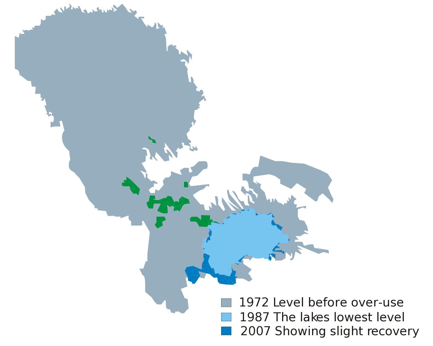
Blank map of Africa W3C-validity not checked. |
| 日期 | (UTC) |
| 来源 | |
| 作者 |
|
| 这是一张修改过的图片,这意味着它已在原版本的基础上通过软件进行了编辑,改动内容:cut some portion of the file。其原始版本为:Lake Chad map showing receding water area and level 1972-2007.svg。修改者: Alexchris。
|
许可协议
| 我,本作品著作权人,释出本作品至公有领域。这适用于全世界。 在一些国家这可能不合法;如果是这样的话,那么: 我无条件地授予任何人以任何目的使用本作品的权利,除非这些条件是法律规定所必需的。 |
原始上传日志
This image is a derivative work of the following images:
- File:Lake_Chad_map_showing_receding_water_area_and_level_1972-2007.svg licensed with PD-self
- 2010-02-28T04:33:44Z Chaosdruid 2440x1373 (157736 Bytes) Correcting area displayed to full instead of A4 cutoff
- 2010-02-28T04:29:38Z Chaosdruid 744x1052 (140458 Bytes) {{Information |Description=Blank map of Africa{{ValidSVG}} |Source=*[[:File:Blank_Map-Africa.svg|]] |Date=2010-02-28 04:27 (UTC) |Author=*[[:File:Blank_Map-Africa.svg|]]: [[User:Andreas 06|Andreas 06]] *derivative work: ~~~ |
Uploaded with derivativeFX
文件历史
点击某个日期/时间查看对应时刻的文件。
| 日期/时间 | 缩略图 | 大小 | 用户 | 备注 | |
|---|---|---|---|---|---|
| 当前 | 2023年6月12日 (一) 07:01 | | 1,400 × 1,120(94 KB) | Newbamboo | new |
| 2011年10月31日 (一) 15:37 |  | 1,400 × 1,249(85 KB) | Alexchris | == {{int:filedesc}} == {{Information |Description=Blank map of Africa{{ValidSVG}} |Source=*File:Lake_Chad_map_showing_receding_water_area_and_level_1972-2007.svg |Date=2011-10-31 15:35 (UTC) |Author=*[[:File:Lake_Chad_map_showing_receding_water_area |
文件用途
以下页面使用本文件:
全域文件用途
以下其他wiki使用此文件:
- cs.wikipedia.org上的用途
- en.wikipedia.org上的用途
- es.wikipedia.org上的用途
- gl.wikipedia.org上的用途
- sc.wikipedia.org上的用途
- uk.wikipedia.org上的用途