File:Europa 1815.svg

此SVG文件的PNG预览的大小:589 × 599像素。 其他分辨率:236 × 240像素 | 472 × 480像素 | 755 × 768像素 | 1,007 × 1,024像素 | 2,013 × 2,048像素 | 1,340 × 1,363像素。
原始文件 (SVG文件,尺寸为1,340 × 1,363像素,文件大小:554 KB)
摘要
| 描述 |
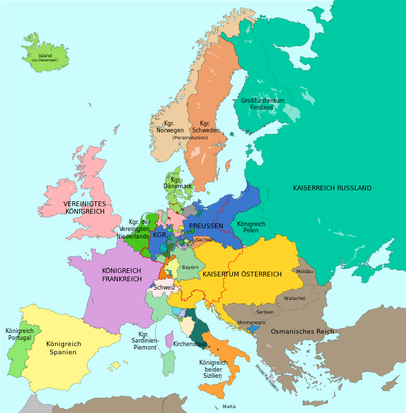
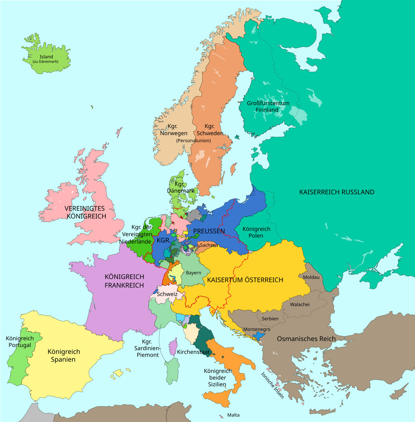
Deutsch: Europa im Jahr 1815 nach dem Wiener Kongress. Großmächte in GROSSBUCHSTABEN.
Russland
Frankreich
Vereinigtes Königreich
Preußen
Österreich und habsburgischer Besitz
Grenze des Deutschen Bundes (1815) English: Map of Europe 1815 after the Congress of Vienna. Great Powers in CAPITAL LETTERS.
Russia
France
United Kingdom
Prussia
Austria and Habsburg possessions
Border of the German Confederation (1815) Català: Mapa d'Europa 1815 després del Congrés de Viena. Grans potències en lletra majúscula.
Rússia
França
Regne Unit
Prússia
Àustria i possessions dels Habsburg
Frontera de la Confederació Alemanya (1815) |
| 日期 | (UTC), largely revised version: 2016-10-06 |
| 来源 |
本文件衍生自: A blank map of Europe ca. 1815.svg: File:A blank map of Europe ca. 1815.svg |
| 作者 |
|
| 其他版本 |
|
| SVG开发 |


|
This SVG file contains embedded text that can be translated into your language, using any capable SVG editor, text editor or the SVG Translate tool. For more information see: About translating SVG files. |
_en.png)
.png)
.jpg)
许可协议

|
已授权您依据自由软件基金会发行的无固定段落及封面封底文字(Invariant Sections, Front-Cover Texts, and Back-Cover Texts)的GNU自由文件许可协议1.2版或任意后续版本的条款,复制、传播和/或修改本文件。该协议的副本请见“GNU Free Documentation License”。 |
| 本文件采用知识共享署名-相同方式共享 3.0 未本地化版本许可协议授权。 | ||
| ||
| 本许可协议标签作为GFDL许可协议更新的组成部分被添加至本文件。 |
本文件采用知识共享署名-相同方式共享 2.5 通用许可协议授权。
- 您可以自由地:
- 共享 – 复制、发行并传播本作品
- 修改 – 改编作品
- 惟须遵守下列条件:
- 署名 – 您必须对作品进行署名,提供授权条款的链接,并说明是否对原始内容进行了更改。您可以用任何合理的方式来署名,但不得以任何方式表明许可人认可您或您的使用。
- 相同方式共享 – 如果您再混合、转换或者基于本作品进行创作,您必须以与原先许可协议相同或相兼容的许可协议分发您贡献的作品。
原始上传日志
This image is a derivative work of the following images:
- File:Map-GermanConfederation.svg licensed with Cc-by-sa-2.5, Cc-by-sa-3.0-migrated, GFDL, GFDL-user-en-note
- 2011-01-18T15:49:48Z Beao 9031x7615 (1364487 Bytes) Removed border
- 2007-04-13T19:20:08Z 52 Pickup 9086x7672 (1815864 Bytes) {{Information| |Description= The [[:en:German Confederation|German Confederation]] ([[:de:Deutscher Bund|Deutscher Bund]]) - map from 1820 |Source= Based on map data of the IEG-Maps project (Andreas Kunz, B. Johnen and Joachi
Uploaded with derivativeFX
文件历史
点击某个日期/时间查看对应时刻的文件。
| 日期/时间 | 缩略图 | 大小 | 用户 | 备注 | |
|---|---|---|---|---|---|
| 当前 | 2023年9月15日 (五) 12:46 | | 1,340 × 1,363(554 KB) | Lalpino | File uploaded using svgtranslate tool (https://svgtranslate.toolforge.org/). Added translation for ca. |
| 2016年10月30日 (日) 17:30 |  | 1,340 × 1,363(549 KB) | Furfur | kleine Korrekturen (Fürstentum Birkenfeld, Wetzlar, Freie Stadt Frankfurt, Hessen-Homburg) | |
| 2016年10月22日 (六) 10:19 |  | 1,340 × 1,363(548 KB) | Furfur | Schweden und Norwegen doch verschieden eingefärbt – trotz Personalunion zwei verschiedene Staaten; Algerien und Tunesien in der Farbe des Osmanischen Reichs | |
| 2016年10月20日 (四) 11:07 |  | 1,340 × 1,363(547 KB) | Furfur | Details (u. a. Bild vergrößert, Meeresdarbe heller) | |
| 2016年10月6日 (四) 19:33 |  | 893 × 907(521 KB) | Furfur | Detailkorrektur | |
| 2016年10月6日 (四) 19:26 |  | 893 × 907(521 KB) | Furfur | Details | |
| 2016年10月6日 (四) 19:07 |  | 893 × 907(520 KB) | Furfur | Korrekturen | |
| 2016年10月6日 (四) 18:59 |  | 893 × 907(518 KB) | Furfur | bessere Karte | |
| 2016年9月29日 (四) 16:54 |  | 905 × 762(2.16 MB) | Furfur | Detail (Meer etwas heller) | |
| 2014年12月9日 (二) 16:59 |  | 905 × 762(2.16 MB) | Furfur | + blue coast line |
文件用途
以下页面使用本文件:
全域文件用途
以下其他wiki使用此文件:
- af.wikipedia.org上的用途
- azb.wikipedia.org上的用途
- ca.wikipedia.org上的用途
- de.wikipedia.org上的用途
- en.wikipedia.org上的用途
- eo.wikipedia.org上的用途
- et.wikipedia.org上的用途
- it.wikipedia.org上的用途
- rm.wikipedia.org上的用途
- stq.wikipedia.org上的用途