中國—塔吉克邊界
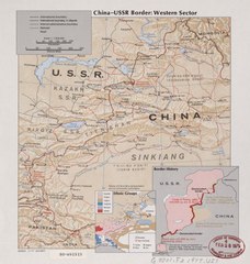
中國—塔吉克邊界長度477 km(296 mi)[1]位於中國新疆與塔吉克的戈爾諾-巴達赫尚自治州穆爾加布區之間。[2]沙伊馬克村軍事基地距離塔吉克的庫利馬(Kulma)通關口岸有不到100公里,距離中國—塔吉克的排依克山口、納茲塔什山口 (中國—塔吉克)、和中國—阿富汗的托克滿蘇達坂不到50公里。

歷史 編輯


1864年俄羅斯帝國與清朝簽訂的《塔城界約》[3][4][5][6][4],規定中俄邊界「行至蔥嶺,靠浩罕界為界」,實際上未涉及塔吉克地段的邊界。1881年簽訂的《中俄伊犁條約》規定中俄兩國在帕米爾的邊界線「照兩國現管之界勘定」。1884年勘界和簽訂《中俄續勘喀什噶爾界約》[4][4],中俄兩國在帕米爾地區分界線的起點從帕米爾北部的阿賴嶺移到了東北部的烏孜別里山口並規定從烏孜別里山口往南,「俄國界線轉向西南,中國界線一直往南」,中間形成一塊「待議區」。大英帝國與俄羅斯帝國爭奪中亞控制之大博弈,1890年簽訂英俄協定。1891年沙俄出兵帕米爾進入「待議區」。1892年進入「中國界線一直往南」這條中國邊界以東的中國領土。1895年3月11日,英俄簽訂了《關於帕米爾地區勢力範圍的協議》[4],劃定兩國在帕米爾的勢力分界線,將興都庫什山北麓與帕米爾南緣之間的狹長地帶劃作兩國間的隔離帶,這條緩衝地帶就是瓦罕走廊。1895年7月俄英兩國開始在帕米爾地區進行勘界活動。清政府在帕米爾劃界問題上堅持原則立場:帕米爾屬於中國,不承認沙俄派兵強佔並同英國瓜分帕米爾的行為。
1999年中華人民共和國和塔吉克共和國簽署了《中華人民共和國和塔吉克共和國關於中塔國界的協定》,劃分了烏孜別里山口以北的中國塔吉克邊界。[7]2000年7月,中塔吉三國簽署了《中塔吉關於三國國界交界點的協定》。2002年5月27日簽訂《中華人民共和國和塔吉克共和國關於中塔國界的補充協定》,劃分了烏孜別里山口以南的中國塔吉克邊界。2011年塔吉克議會批准了1999年與2002年的兩個邊界協定。[8]
2021年塔吉克總統提議中國增加對塔吉克軍隊的軍事援助, 同時為塔吉克軍方興建一處新的軍事基地位於瓦罕走廊西北部塔吉克伊什卡西姆縣(Ishkoshim District)的軍事基地。作為交換,塔吉克將把鄰近中國新疆的穆爾加布縣(Murghob District)沙伊馬克村(Shaymak)的軍事基地完全轉交給中國。 [9]
地理 編輯
中塔國界第四號界點(位於瑪爾坎蘇河水流中心線)是中國最西端。
阿富汗—中國—塔吉克三國國界交界點為海拔5698m的克克拉去考勒峰[10][11][12][13](蘇聯地圖為海拔5518.5m的波瓦洛--什韋科夫斯基峰[14])。這也是阿富汗的最東點。
中塔邊界的唯一公路口岸為庫利馬口岸,中方稱卡拉蘇口岸,闊勒買達坂海拔4,362.7米(14,313英尺)。[15]
歷史上,更南的納茲塔什山口(海拔4476米)與克克敖吊克達坂(蘇聯稱別伊克山口,海拔4742.0米)也可以翻越薩雷闊勒嶺。
中塔邊界西北部的通道有烏孜別里山口[10][16][17](蘇聯稱Pereval Kyzyl-Dzhiik[18][19])等。
地圖 編輯
以下為20世紀中葉中蘇國界塔吉克地段的地圖:
-
![International Map of the World(英語:International Map of the World) (AMS(英語:Army Map Service), 1966)[a]](//upload.wikimedia.org/wikipedia/commons/thumb/a/ae/Txu-oclc-6654394-nj-43-5th-ed.jpg/215px-Txu-oclc-6654394-nj-43-5th-ed.jpg)
-
![中國阿富汗國界(含阿富汗—中國—蘇聯三國國界交界點(英語:List of tripoints)標記為PEAK POVALO SHVEIKOVSKI 5698 (18694)) (1969)[b]](//upload.wikimedia.org/wikipedia/commons/thumb/4/4c/Afghanistan-China_Boundary._4-69._LOC_gm70003373_cropped.jpg/313px-Afghanistan-China_Boundary._4-69._LOC_gm70003373_cropped.jpg) 中國阿富汗國界(含阿富汗—中國—蘇聯三國國界交界點標記為PEAK POVALO SHVEIKOVSKI 5698 (18694)) (1969)[b]
中國阿富汗國界(含阿富汗—中國—蘇聯三國國界交界點標記為PEAK POVALO SHVEIKOVSKI 5698 (18694)) (1969)[b] -
 中蘇邊界帕米爾地區(41,000 km2(16,000 sq mi))中方主張
 -
![邊界地區(DMA, 1980)[c]](//upload.wikimedia.org/wikipedia/commons/thumb/f/fb/Operational_Navigation_Chart_G-7%2C_6th_edition.jpg/331px-Operational_Navigation_Chart_G-7%2C_6th_edition.jpg)
-
![邊界的北部/西部(DMA, 1981)[d]](//upload.wikimedia.org/wikipedia/commons/thumb/b/bb/Txu-pclmaps-oclc-22834566_g-6b.jpg/321px-Txu-pclmaps-oclc-22834566_g-6b.jpg)
-
![邊界的南部/東部(DMA, 1984)[e]](//upload.wikimedia.org/wikipedia/commons/thumb/a/a1/Txu-pclmaps-oclc-22834566_g-7a.jpg/335px-Txu-pclmaps-oclc-22834566_g-7a.jpg)
-
![中蘇國界(塔吉克地段)(DMA, 1988)[f]](//upload.wikimedia.org/wikipedia/commons/thumb/1/1d/Txu-oclc-224033229-nj43-06.jpg/321px-Txu-oclc-224033229-nj43-06.jpg)
-
![中塔邊界(DMA, 1992)[g]](//upload.wikimedia.org/wikipedia/commons/thumb/9/92/Txu-oclc-224033229-nj43-10.jpg/318px-Txu-oclc-224033229-nj43-10.jpg)
-
 中塔邊界,公路通過庫利馬口岸(中方為卡拉蘇口岸) (2001)
 -
 中塔邊界
中塔邊界
![International Map of the World(英語:International Map of the World) (AMS(英語:Army Map Service), 1966)[a]](/wiki/File:Txu-oclc-6654394-nj-43-5th-ed.jpg)
![中國阿富汗國界(含阿富汗—中國—蘇聯三國國界交界點(英語:List of tripoints)標記為PEAK POVALO SHVEIKOVSKI 5698 (18694)) (1969)[b]](/wiki/File:Afghanistan-China_Boundary._4-69._LOC_gm70003373_cropped.jpg)

![邊界地區(DMA, 1980)[c]](/wiki/File:Operational_Navigation_Chart_G-7,_6th_edition.jpg)
![邊界的北部/西部(DMA, 1981)[d]](/wiki/File:Txu-pclmaps-oclc-22834566_g-6b.jpg)
![邊界的南部/東部(DMA, 1984)[e]](/wiki/File:Txu-pclmaps-oclc-22834566_g-7a.jpg)
![中蘇國界(塔吉克地段)(DMA, 1988)[f]](/wiki/File:Txu-oclc-224033229-nj43-06.jpg)
![中塔邊界(DMA, 1992)[g]](/wiki/File:Txu-oclc-224033229-nj43-10.jpg)


參見 編輯
註釋 編輯
- ^ From map: "DELINEATION OF INTERNATIONAL BOUNDARIES MUST NOT BE CONSIDERED AUTHORITATIVE"
- ^ From map: "NAMES AND BOUNDARY REPRESENTATION ARE NOT NECESSARILY AUTHORITATIVE"
- ^ From map: "The representation of international boundaries is not necessarily authoritative."
- ^ From map: "The representation of international boundaries is not necessarily authoritative"
- ^ From map: "The representation of international boundaries is not necessarily authoritative"
- ^ From map: "THE REPRESENTATION OF INTERNATIONAL BOUNDARIES IS NOT NECESSARILY AUTHORITATIVE."
- ^ From map: "BOUNDARY REPRESENTATION IS NOT NECESSARILY AUTHORITATIVE."
參考文獻 編輯
| 維基共享資源上的相關多媒體資源:中國—塔吉克邊界 |
| 中文維基文庫中相關的原始文獻: 中华人民共和国和塔吉克斯坦共和国关于中塔国界的协定 |
| 中文維基文庫中相關的原始文獻: 中华人民共和国和塔吉克斯坦共和国关于中塔国界的补充协定 |
- ^ FIELD LISTING :: LAND BOUNDARIES. The World Factbook. [30 January 2020].
China total: 22,457 km border countries (15):{...}Tajikistan 477 km, {...}Tajikistan total: 4,130 km border countries (4): {...}China 477 km, {...
} - ^ CIA World Factbook - Tajikistan, 23 September 2018[失效連結]
- ^ Articles 2 and 3 in the Russian text of the treaty
- ^ 4.0 4.1 4.2 4.3 4.4 International Boundary Study No. 64 – China-USSR Boundary (PDF), 13 February 1978 [23 September 2018], 原始內容存檔於2014-08-17
- ^ (See the map)
- ^ The Lost Frontier: the treaty maps that changed Qing's northwestern boundaries. [2020-03-06]. (原始內容存檔於2015-03-13).
- ^ 中华人民共和国和塔吉克斯坦共和国关于中塔国界的协定. 全國人大. 人大公報. [2021-06-01]. (原始內容存檔於2021-02-23).
- ^ Alex Sodiqov. Tajikistan cedes disputed land to China. Eurasia Daily Monitor (Jamestown Foundation). 24 January 2011, 8 (16) [23 September 2018].
On January 12, the lower house of the Tajik parliament voted to ratify the 2002 border demarcation agreement, handing over 1,122 square kilometers (433 square miles) of mountainous land in the remote Pamir Mountains (www.asiaplus.tj, January 12). The ceded land represents about 0.8 percent of the country’s total area of 143,100 square kilometers (55,250 square miles).{...}At the time of independence, Tajikistan inherited three disputed border segments, constituting about 28,500 square kilometers (11,000 square miles), which China and the Soviet Union had been unable to resolve. In 1999, Tajikistan and China signed a border demarcation agreement, defining the border in two of the three segments. Under the 1999 deal, Dushanbe ceded about 200 square kilometers (77 square miles) of land to Beijing (http://www.ca-oasis.info/oasis/?jrn=109&id=817).
- ^ 白樺. 中国控制瓦罕走廊防卫新疆 利用阿富汗局势加强在帕米尔高原的存在. 美國之音. 2022-10-29 [2022-10-29]. (原始內容存檔於2022-02-20) (中文).
作為交換,塔吉克將把鄰近中國新疆的穆爾加布縣沙伊馬克村的軍事基地完全轉交給中國。中國甚至可以擁有基地的所有權,而不必支付租金。
- ^ 10.0 10.1 China Report Political, Sociological and Military Affaris No. 363 (PDF). United States Joint Publications Research Service: 1. 18 November 1982 [11 January 2020]. (原始內容存檔 (PDF)於2020-01-11) –透過Defense Technical Information Center.
If we open up the Atlas of the People's Republic of China we will find that the region of the Pamir, the western extremity of Xinjiang, from the Wuzibieli [Uzbel] Pass1 to the south down to the Kekelaqukaole Peak (which the Soviet Russians call "Pavel Shveikovsky Peak") is designated as a not limited area.
- ^ 阿富汗. State Ethnic Affairs Commission. 6 July 2004. (原始內容存檔於4 December 2008) (中文(簡體)).
中阿边界{...}南起中、巴、阿3国交界处的5587山峰,沿穆斯塔格山脉分水岭北行至克克拉去考勒峰。
- ^ Kamoludin Abdullaev. Historical Dictionary of Tajikistan 3. Rowman & Littlefield. 2018: 92. ISBN 9781538102527 –透過Google Books.
CHINA-TAJIK BORDER.{...}This mountainous boundary runs along the Sarikol mountain range in eastern Tajikistan, reaching in Pamir the Afghan border at the Povalo-Shveikovskogo peak (5,543 meters above sea level).
- ^ NJ 43 Su-fu [U.S.S.R., China, Afghanistan, Pakistan, State of Jammu and Kashmir] Series 1301, Edition 5-AMS. Washington, D. C.: Army Map Service. March 1967 [2020-03-06]. (原始內容存檔於2019-10-13) –透過Perry–Castañeda Library Map Collection (英語).
Pik Povalo-Shveikovskogo
- ^ 中华人民共和国和阿富汗王国边界条约. 22 November 1963 [2020-12-12]. (原始內容存檔於2020-11-04) –透過Wikisource (中文).
到高程为5698米的克克拉去考勒峰(阿方图称波万洛什维科夫斯基峰)。
- ^ Caravanistan - Tajikistan border crossings, [23 September 2018], (原始內容存檔於2020-07-01)
- ^ 夏征農; 陳至立 (編). 辞海:第六版彩图本 [Cihai (Sixth Edition in Color)]. 上海. Shanghai: 上海辭書出版社. Shanghai Lexicographical Publishing House. September 2009: 2187. ISBN 9787532628599 (中文).
乌孜别里山口
- ^ Uzbel Shankou (Approved - N)位於GEOnet名稱服務的結果, United States National Geospatial-Intelligence Agency
- ^ Pereval Kyzyl-Dzhiik (Approved - N)位於GEOnet名稱服務的結果, United States National Geospatial-Intelligence Agency
- ^ China-USSR border, western sector.. [2020-03-06]. (原始內容存檔於2020-01-16) –透過Library of Congress.
Wu-tzu-pieh-li Shan-k'ou (Pereval Kyzyl-Dzhiik)
![NJ 43 Su-fu [U.S.S.R., China, Afghanistan, Pakistan, State of Jammu and Kashmir] Series 1301, Edition 5-AMS](http://legacy.lib.utexas.edu/maps/imw/txu-oclc-6654394-nj-43-5th-ed.jpg)