File:California Congressional Districts, 113th Congress.tif

此 TIF 檔案的 PNG 預覽的大小:612 × 599 像素。 其他解析度:245 × 240 像素 | 490 × 480 像素 | 784 × 768 像素 | 1,045 × 1,024 像素 | 2,441 × 2,391 像素。
原始檔案 (2,441 × 2,391 像素,檔案大小:1.41 MB,MIME 類型:image/tiff)
摘要
| 描述 |
English: Map of Congressional Districts in the state of California, reflecting district boundaries current to the 113th United States Congress. |
| 日期 | |
| 來源 | National Atlas of the United States (http://nationalatlas.gov/printable/congress.html |
| 作者 | Department of the Interior |
| 其他版本 | United States Census Bureau (https://www2.census.gov/geo/maps/cong_dist/uswall/cd116/CD116_US_WallMap.pdf) |
授權條款
This image or file is a work of a United States Census Bureau employee, taken or made as part of that person's official duties. As a work of the U.S. federal government, the image is in the public domain.
|
 |
檔案歷史
點選日期/時間以檢視該時間的檔案版本。
| 日期/時間 | 縮圖 | 尺寸 | 用戶 | 備註 | |
|---|---|---|---|---|---|
| 目前 | 2014年2月2日 (日) 06:00 | 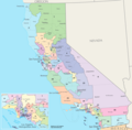 | 2,441 × 2,391(1.41 MB) | 7partparadigm | User created page with UploadWizard |
檔案用途
下列4個頁面有用到此檔案:
全域檔案使用狀況
以下其他 wiki 使用了這個檔案:
- en.wikipedia.org 的使用狀況
- fa.wikipedia.org 的使用狀況
- fr.wikipedia.org 的使用狀況
- ru.wikipedia.org 的使用狀況
- tr.wikipedia.org 的使用狀況
- uk.wikipedia.org 的使用狀況