File:Dennis 2005-07-10 1615Z (alternate).jpg

原始檔案 (6,800 × 8,800 像素,檔案大小:9.37 MB,MIME 類型:image/jpeg)
| 警告 | 部分瀏覽器在瀏覽此圖片的完整大小時可能會遇到困難:該圖片中有數量巨大的像素點,可能無法完全載入或者導致您的瀏覽器停止回應。 |
|---|
摘要
| 描述 |
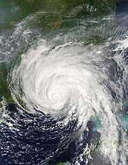
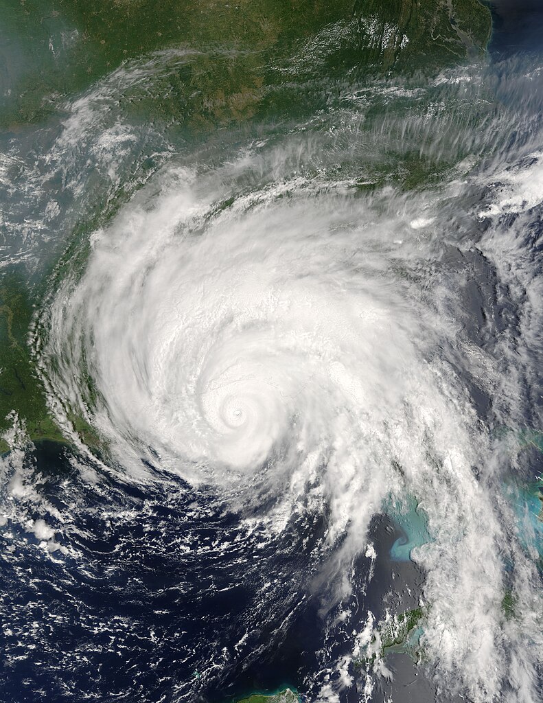
Hurricane Dennis was bearing down on the Gulf Coast of the United States on July 10, 2005, at 12:15 p.m. (16:15 UTC) when the Moderate Resolution Imaging Spectroradiometer on NASA's Terra satellite captured this image. With winds of 140 miles per hour (225 kph), Dennis was a powerful Category 4 storm just hours away from making landfall. At the time this image was taken, the eye of the storm was about 55 miles (90 kilometers) south, southeast of Pensacola, Florida, and the storm was moving northwest at about 18 miles per hour (29 kph). The size of the storm put clouds of rain over most of the southeastern United States well before the storm came ashore. In this image, Dennis covers all of Florida, Alabama, Mississippi, and stretches over parts of Louisiana. The northern fringes of the storm appear to be over Tennessee and North Carolina. For additional information and warnings about this storm, please visit the National Hurricane Center. This image is available in additional resolutions from the MODIS Rapid Response Team. |
|||||
| 日期 | ||||||
| 來源 | http://earthobservatory.nasa.gov/NaturalHazards/natural_hazards_v2.php3?img_id=12947 | |||||
| 作者 | NASA image courtesy Jacques Descloitres, MODIS Rapid Response Team, NASA GSFC | |||||
| 授權許可 (重用此檔案) |
|
|||||
| 其他版本 | Image:Hurricane Dennis 7102005.jpg |

.jpg?uselang=zh-mo)
.jpg?uselang=zh-mo)
.jpg?action=history&uselang=zh-mo)
.jpg)
檔案歷史
點選日期/時間以檢視該時間的檔案版本。
| 日期/時間 | 縮圖 | 尺寸 | 用戶 | 備註 | |
|---|---|---|---|---|---|
| 目前 | 2006年10月22日 (日) 01:20 | | 6,800 × 8,800(9.37 MB) | Good kitty | == Summary == {{Information |Description=Hurricane Dennis was bearing down on the Gulf Coast of the United States on July 10, 2005, at 12:15 p.m. (16:15 UTC) when the Moderate Resolution Imaging Spectroradiometer on NASA's Terra satellite captured this im |
檔案用途
下列2個頁面有用到此檔案:
全域檔案使用狀況
以下其他 wiki 使用了這個檔案:
- ar.wikipedia.org 的使用狀況
- ca.wikipedia.org 的使用狀況
- en.wikipedia.org 的使用狀況
- Hurricane Dennis
- Timeline of the 2005 Atlantic hurricane season
- Portal:Cuba/Did you know
- Portal:Cuba/Did you know/9
- List of the wettest tropical cyclones in the United States
- Effects of Hurricane Dennis in Florida
- Effects of Hurricane Dennis in Alabama
- Effects of Hurricane Dennis in Georgia
- Effects of Hurricane Dennis in Mississippi
- Portal:Tropical cyclones/Featured article/Effects of Hurricane Dennis in Florida
- Template:Hurricane Dennis series
- List of natural disasters in Haiti
- Effects of Hurricane Dennis in Jamaica
- User:IPhonehurricane95/Picture of the day/Hurricane Dennis
- Meteorological history of Hurricane Dennis
- Effects of Hurricane Dennis in Haiti
- es.wikipedia.org 的使用狀況
- eu.wikipedia.org 的使用狀況
- fr.wikipedia.org 的使用狀況
- ht.wikipedia.org 的使用狀況
- hu.wikipedia.org 的使用狀況
- no.wikipedia.org 的使用狀況
- pl.wikipedia.org 的使用狀況
- pt.wikipedia.org 的使用狀況
- ro.wikipedia.org 的使用狀況
- simple.wikipedia.org 的使用狀況
- sv.wikipedia.org 的使用狀況
- www.wikidata.org 的使用狀況
.jpg)