File:United States Congressional Districts in New Hampshire, 1973 – 1982.tif

此 TIF 檔案的 PNG 預覽的大小:605 × 599 像素。 其他解析度:242 × 240 像素 | 485 × 480 像素 | 810 × 802 像素。
原始檔案 (810 × 802 像素,檔案大小:1.02 MB,MIME 類型:image/tiff)
摘要
| 描述 |
English: Statewide boundaries for United States congressional districts in New Hampshire, 1973 – 1982. Map color key is provided inside the image. |
| 日期 | |
| 來源 | US Department of the Interior, public data retrieved from http://cdmaps.polisci.ucla.edu on October 18, 2014. |
| 作者 | Authors: 1) All GIS data presented in this project was originally collected and published by the United States Department of the Interior. 2) US district GIS shapefile data created in association with the UCLA by Jeffrey B. Lewis, Brandon DeVine, Lincoln Pitcher, and Kenneth C. Martis. (2013) Digital Boundary Definitions of United States Congressional Districts, 1789-2012. 3) Data was rendered using ArcGIS® software by Esri. 4) File developed for use on Wikipedia and elsewhere by 7partparadigm. |
授權條款
| This image or media file contains material based on a work of a United States Department of the Interior employee, created as part of that person's official duties. As a work of the U.S. federal government, such work is in the public domain in the United States. See the Department of the Interior copyright policy for more information. |  |
檔案歷史
點選日期/時間以檢視該時間的檔案版本。
| 日期/時間 | 縮圖 | 尺寸 | 用戶 | 備註 | |
|---|---|---|---|---|---|
| 目前 | 2014年10月30日 (四) 23:56 | 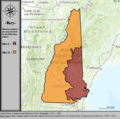 | 810 × 802(1.02 MB) | 7partparadigm | User created page with UploadWizard |
檔案用途
下列頁面有用到此檔案:
全域檔案使用狀況
以下其他 wiki 使用了這個檔案:
- en.wikipedia.org 的使用狀況
- it.wikipedia.org 的使用狀況