File:Harpers Ferry WV aerial.jpg
此为最大尺寸。
Harpers_Ferry_WV_aerial.jpg (413 × 320像素,文件大小:57 KB,MIME类型:image/jpeg)
摘要
| 描述 |
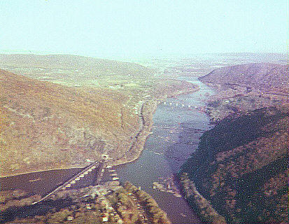
English: The confluence of the Potomac and Shenandoah Rivers, at Harpers Ferry 35px. Aerial view looking east towards Maryland, with the CSX RR bridge crossing the river. |
| 日期 | |
| 来源 | 自己的作品 (Original text: User:JGHowes) |
| 作者 |
User:JGHowes, photographer |
| 授权 (二次使用本文件) |
© by James G. Howes, October, 1974. Copyright holder must be properly attributed. |
许可协议

|
本文件的著作权人,James G. Howes,允许任何人在适当地表明著作权人的姓名的前提下,以任何目的使用本文件。传播,演绎作品,商业用途及所有其他用途被允许。 |
署名:
James G. Howes
|
原始上传日志
Transferred from en.wikipedia to Commons by Fredlyfish4 using CommonsHelper.
The original description page was here. All following user names refer to en.wikipedia.
- 2008-01-23 03:06 JGHowes 413×320× (58313 bytes) {{Information |Description=The [[confluence]] of the [[Potomac]] and [[Shenandoah River]]s, at [[Harpers Ferry, West Virginia]] [[Image:Flag of West Virginia.svg|35px]]. Aerial view looking east towards [[Maryland]], with the [[CSX Transportation|CSX RR]]
文件历史
点击某个日期/时间查看对应时刻的文件。
| 日期/时间 | 缩略图 | 大小 | 用户 | 备注 | |
|---|---|---|---|---|---|
| 当前 | 2012年10月9日 (二) 01:08 | | 413 × 320(57 KB) | File Upload Bot (Magnus Manske) | Transfered from en.wikipedia by User:Fredlyfish4 using CommonsHelper |
文件用途
以下页面使用本文件:
全域文件用途
以下其他wiki使用此文件:
- el.wikipedia.org上的用途
- en.wikipedia.org上的用途
- he.wikipedia.org上的用途
- ja.wikipedia.org上的用途
- sh.wikipedia.org上的用途
- sr.wikipedia.org上的用途
- tr.wikipedia.org上的用途