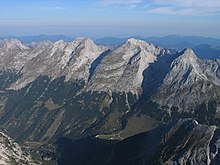
东卡文德尔峰
47°26′41″N 11°25′17″E / 47.44472°N 11.42139°E

东卡文德尔峰(德语:Östliche Karwendelspitze)是中欧的山峰,位于奥地利和德国接壤的边境,属于卡文德尔山脉的一部分,海拔高度2,537米,每年平均降雨量1,666毫米,人类在1870年7月4日首次登顶。
参考资料
编辑- Östliche Karwendelspitze - peakbagger. peakbagger.com. [15 March 2015]. (原始内容存档于2020-01-16).
- Tour description (页面存档备份,存于互联网档案馆)
- Ski tour from Hinterriß (页面存档备份,存于互联网档案馆)
- Report of the first ascent of the Östlichen Karwendelspitze and the Vogelkarspitze on 4 July 1870 (页面存档备份,存于互联网档案馆) by Hermann von Barth (Chapter XIX from the book: Aus den Nördlichen Kalkalpen, Gera 1874, p. 420 ff.)
- Mountain tour with GPS Track (页面存档备份,存于互联网档案馆)
| 这是一篇奥地利地理小作品。您可以通过编辑或修订扩充其内容。 |
| 这是一篇德国地理小作品。您可以通过编辑或修订扩充其内容。 |