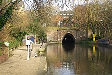
攝政運河
攝政運河(英語:Regent's Canal)是英格蘭倫敦市中心北部的一條運河,長8.6英里(13.8公里)[1]。它由約翰·納什始建於1812年,具體設計由詹姆斯·摩根執行,本是一條航運運河,但隨著航運的衰落,現在基本不再使用,但沿河的小路被開發為國家自行車網的一號路線,成為比較繁忙的自行車通勤路線,英國國家電網也在沿河小路下鋪設。
| 攝政運河 Regent's Canal | |
|---|---|
 | |
| 規格 | |
| 長度 | 8.6英里(13.8公里) |
| 船隻最大長度 | 78英尺0英寸(23.77米) |
| 最大船幅 | 14英尺6英寸(4.42米) |
| 船閘數 | 13 |
| 狀態 | 使用中 |
| 航運管理機構 | Canal and River Trust |
| 歷史 | |
| 總工程師 | 詹姆斯·摩根 |
| 決定建設日期 | 1812 |
| 始建日期 | 1812年10月14日 |
| 首航日期 | 1816年 |
| 竣工日期 | 1820年8月1日 |
| 地理 | |
| 起點 | Paddington Arm (Grand Union Canal) |
| 終點 | 泰晤士河 (萊姆豪斯) |
| 支流 | Hertford Union Canal Limehouse Cut |
參考文獻
編輯- ^ Regent's Canal. [2022-02-22]. (原始內容存檔於2022-02-22).
外部連結
編輯- 維基共享資源上的相關多媒體資源:攝政運河
- Canalplan AC Gazetteer: Grand Union Canal (Regent's Canal)
- Plan of Grand Union Canal (Regent's Canal) (頁面存檔備份,存於網際網路檔案館) with links to places of interest near each lock, basin, and bridge.
- Photographs of Regent's Canal (頁面存檔備份,存於網際網路檔案館)
- Regent's Canal interactive map (頁面存檔備份,存於網際網路檔案館)
- More background information and history of the Regent's Arm (頁面存檔備份,存於網際網路檔案館)
- Regent's Canal, Camden markets, history and pictures (頁面存檔備份,存於網際網路檔案館)
- Regent's Canal Walk: Little Venice to Limehouse Basin (Walking Guide) (頁面存檔備份,存於網際網路檔案館)