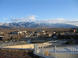
瓦薩奇山脈
瓦薩奇山脈(Wasatch Range)是位於美國西部的一座山脈,全長約160英里(260公里),起於猶他州和愛達荷州交界處,向南至猶他州中部。瓦薩奇山脈是洛基山的西界,也是大盆地的東界[1]。瓦薩奇這一名稱來自於當地原住民[2][3]。猶他州的大部分人口居住在瓦薩奇山脈附近地區。
| Wasatch Range | |
|---|---|
 自鹽湖城公共圖書館望瓦薩奇山脈 | |
| 最高點 | |
| 山峰 | Mount Nebo |
| 海拔 | 11,928英尺(3,636公尺) |
| 地理 | |
| 國家 | 美國 |
| States | 猶他和愛達荷 |
| 山脈 | 洛基山 |
參考資料
編輯- ^ Hiking the Wasatch, John Veranth, 1988, Salt Lake City, ISBN 978-0-87480-628-1
- ^ Fuller, Craig. Wasatch County. Utah History Encyclopedia. [November 28, 2008]. (原始內容存檔於2005年11月3日).
- ^ Bright, William. Native American Placenames of the United States. University of Oklahoma Press. 2004: 549 [2016-07-15]. ISBN 978-0-8061-3598-4. (原始內容存檔於2017-02-20).
- Geology of Utah, William Lee Stokes, Utah Museum of Natural History, Salt Lake City, 1986.
- Wasatch Quartzite, John Gottman, Salt Lake City, 1979.
- Wasatch Tours, Alexis Kelner & Dave Hanscom, Wasatch Publishers, Salt Lake City, 1976.
- Flora of the Central Wasatch Front, Utah. L. Arnow, B. Albee, & A Wycoff, University of Utah, Salt Lake City, 1980.
- Gori, P.L. and Hays, W.W. (Eds.) (2000). Assessment of regional earthquake hazards and risk along the Wasatch Front, Utah [U.S. Geological Survey Professional Paper 1500-K-R]. Reston, VA: U.S. Department of the Interior, U.S. Geological Survey.