Testing map functionality
編輯
Label is bold
photo and map_relief not specified
編輯
relief=0
編輯
map_relief=1 and no name
編輯
Hauhungatahi
編輯
Mount Fuji w/o photo or map
編輯
Mount Fuji with photo
編輯
Mount Baker
編輯
Sunwapta Peak
編輯
Test of an infobox without a photo.
Mount Fernow
編輯
Another photo-free test case
Aiguille de Tré la Tête
編輯
Test rounding of elevation and prominence
Popular range articles
編輯
Himalayas
編輯
Appalachian Mountains
編輯
Alps
編輯
Andes
編輯
左右對比| {{Infobox mountain}} | {{Infobox mountain/sandbox}} |
|---|
| Andes |
|---|
|  | | 最高點 |
|---|
| 山峰 | Aconcagua (Las Heras Department, Mendoza, Argentina) |
|---|
| 海拔 | 6,962公尺(22,841英尺) |
|---|
| 座標 | 32°39′10″S 70°0′40″W / 32.65278°S 70.01111°W / -32.65278; -70.01111 |
|---|
| 規模 |
|---|
| 長度 | 7,000公里(4,300英里) |
|---|
| 寬度 | 500公里(310英里) |
|---|
| 地理 |
|---|
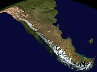 Composite satellite image of the southern Andes
| | 國家 | Argentina、Bolivia、Chile、Colombia、Ecuador、Peru和Venezuela |
|---|
| Settlements | Bogotá, Santiago, Medellín, La Paz, Cali, Quito, Pasto, Mérida, Arequipa, Mendoza, Cuenca, Cochabamba, Pereira, Ibagué, Salta, Manizales, Cúcuta, Cusco and Bucaramanga |
|---|
|
|
Sierra Nevada
編輯
Catskill Mountains
編輯
左右對比| {{Infobox mountain}} | {{Infobox mountain/sandbox}} |
|---|
| Catskill Mountains |
|---|
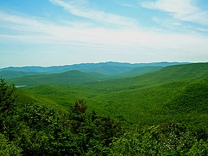 Slide Mountain and the peaks around it as seen from Twin Mountain in the northern Catskills. | | 最高點 |
|---|
| 山峰 | Slide Mountain (S of Shandaken) |
|---|
| 海拔 | 4,154英尺(1,266公尺) |
|---|
| 座標 | 41°59′55″N 74°23′11″W / 41.99861°N 74.38639°W / 41.99861; -74.38639 |
|---|
| 規模 |
|---|
| 長度 | 111英里(179公里) N/S |
|---|
| 寬度 | 102英里(164公里) E/W |
|---|
| 面積 | 15,259平方英里(39,520平方公里) |
|---|
| 地理 |
|---|
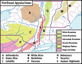 Map of the main regions of the northeast Appalachians, with the Catskills as "C".
| | 國家 | United States |
|---|
| 州或邦 | New York |
|---|
| 地區 | Hudson Valley |
|---|
| Counties | Ulster, Greene, Sullivan, Delaware and Schoharie |
|---|
| Communities | Hunter, Tannersville, Monticello and Liberty |
|---|
| 山脈 | Appalachian |
|---|
| 邊界 | Poconos and Shawangunk Ridge |
|---|
| 地質 |
|---|
| 岩石年代 | Devonian和Mississippian |
|---|
| 岩石類型 | Sedimentary |
|---|
|
|
Unusual range cases
編輯
map only, dim parameter
編輯
Range coordinates
編輯
Range coordinates that are difficult to round
編輯
Range coordinates specified only by degrees
編輯
Country_type parameter
編輯
Topo map
編輯
References
編輯


